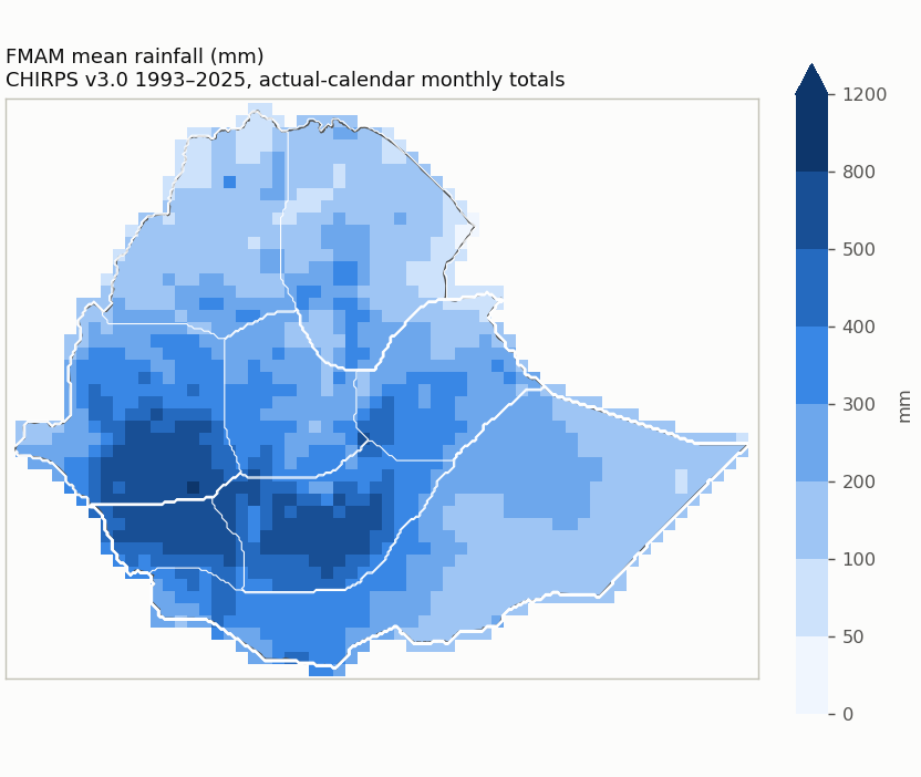
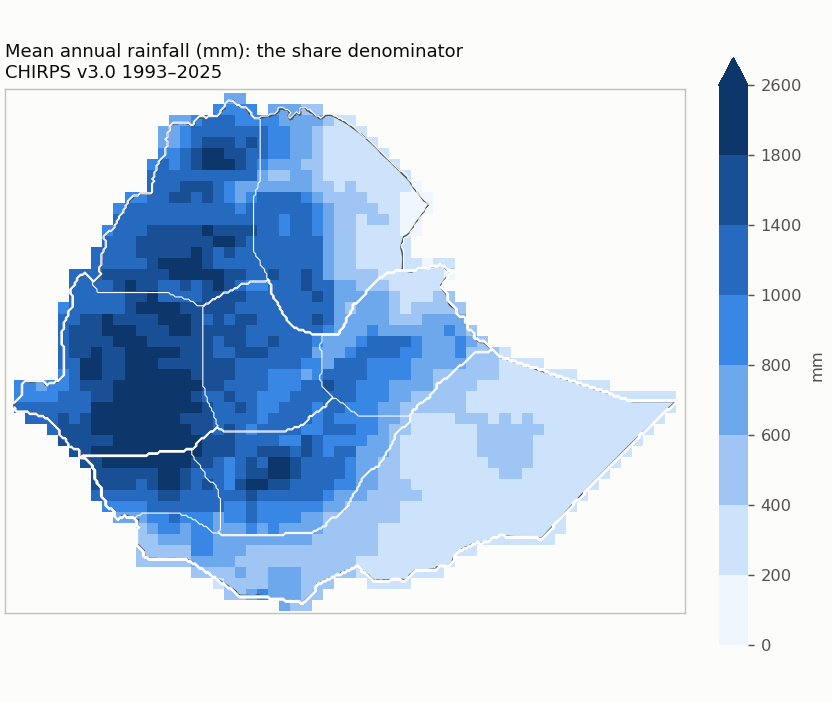
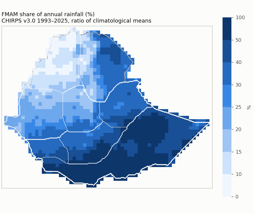
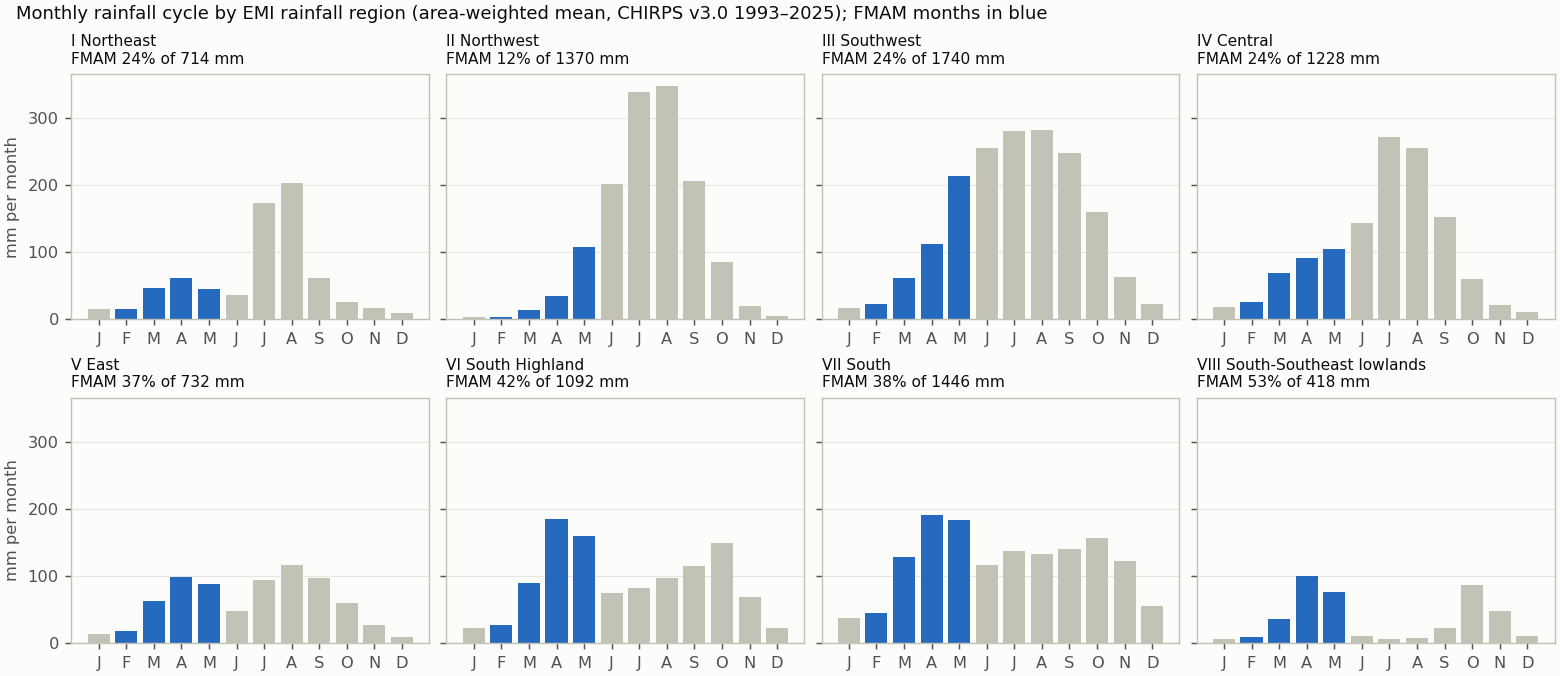
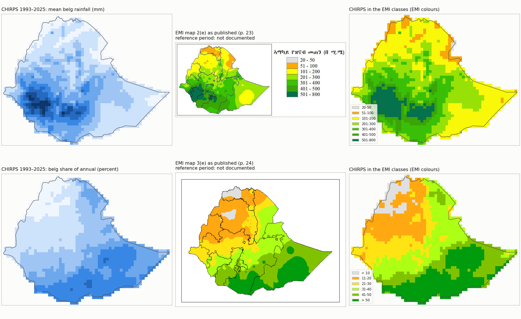
Where does a season's rain matter? Before a forecast domain is chosen, this review computes the observed climatology (seasonal
total, annual total and the season's share), compares it with EMI's published long-term maps, and tests every combination of rainfall
and annual-share cutoffs. Cutoffs are chosen for what the domain means climatologically, never to improve a forecast score.
FMAM climatology from CHIRPS v3.0 1993–2025 · built 2026-10-10 · Full review report
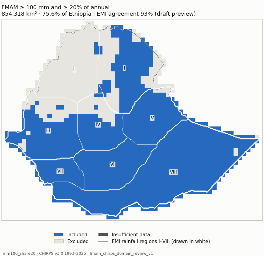
Selected domain: mm100_share20 — Adopted 2026-10-10 as the broad FMAM working domain for Ethiopia: cells where FMAM contributes both a substantial amount (>= 100 mm) and a substantial share (>= 20%) of annual rainfall, i.e. a broad rainfall-contribution domain. The two cutoffs also coincide with EMI legend class breaks (101-200 mm; 21-30 %), which makes a visual comparison with EMI maps 2(e)/3(e) convenient; that comparison is visual and unreviewed and does not independently validate the thresholds. Stable against the 1996-2025 baseline. The included share of Ethiopia describes this rule, not an official estimate of Belg-dependent area.
Climatology References Candidate domains Assessment
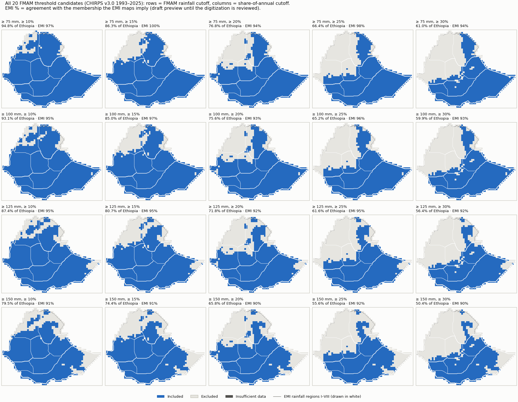
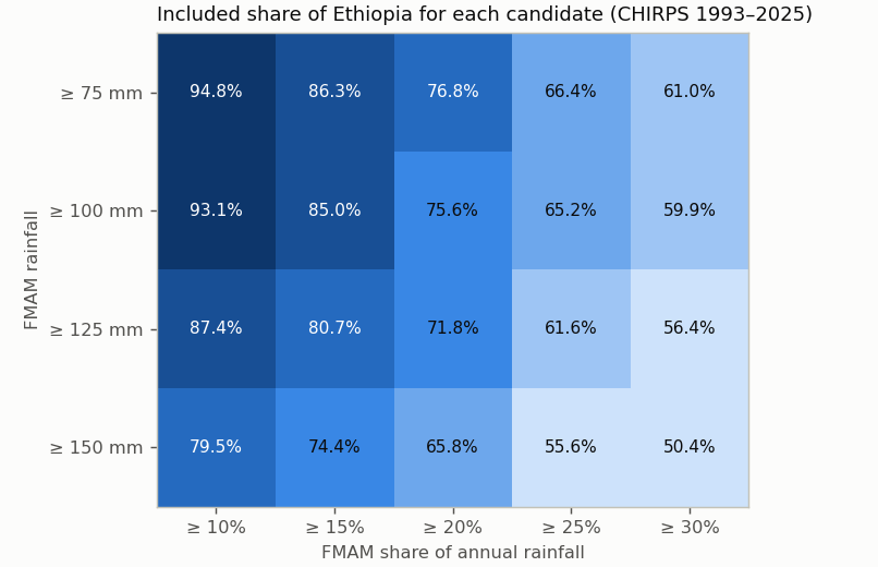
FMAM rainfall ≥ 75 mm ≥ 100 mm ≥ 125 mm ≥ 150 mm
Share of annual ≥ 10% ≥ 15% ≥ 20% ≥ 25% ≥ 30%
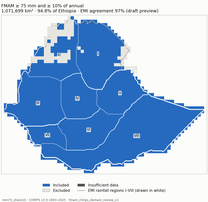
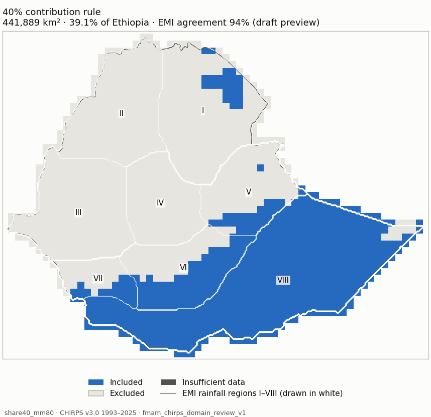
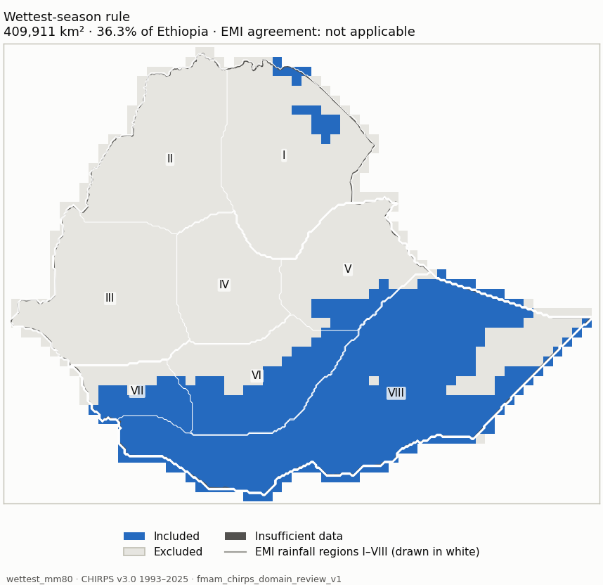
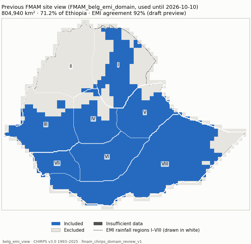
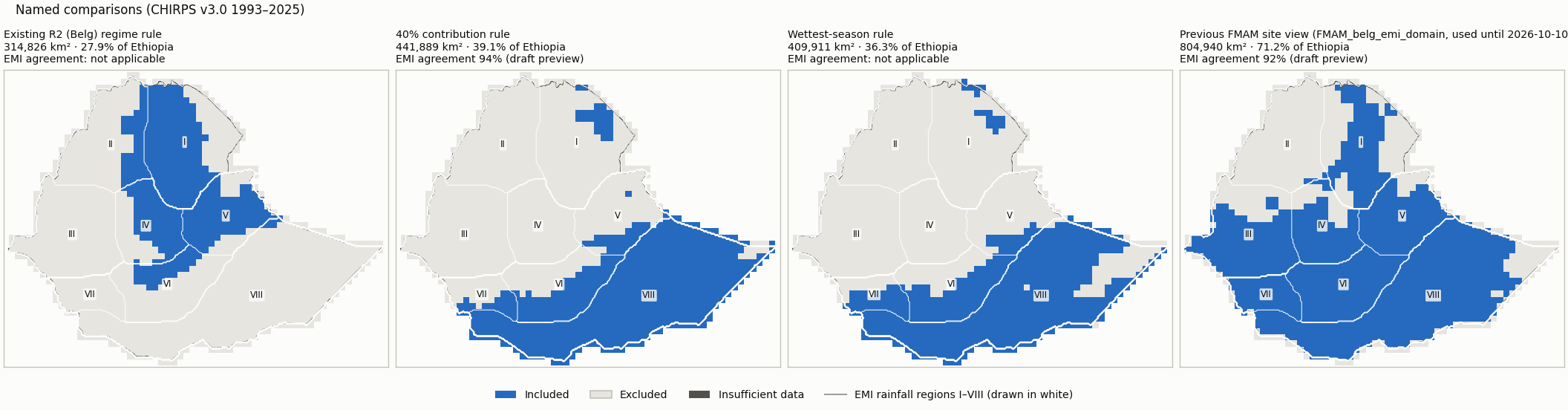
Comparison — threshold candidates — Existing R2 (Belg) regime rule: R2 membership, FMAM >= 80 mm, patches < 3 cells removed 40% contribution rule: FMAM >= 40% of annual and >= 80 mm (no cleanup) Wettest-season rule: FMAM wetter than JJAS and ONDJ, >= 80 mm (no cleanup) Previous FMAM site view (FMAM_belg_emi_domain, used until 2026-10-10): >= 20% and >= 100 mm from the 365-day cycle, patches < 3 cells removed Candidate mm75_share10 (blue: included; dark grey: insufficient data) mm75_share10 Measure Value Included area 1,071,699 km² (94.8% of Ethiopia) Agreement with EMI-implied membership 97% (visual_only (draft preview); undecided 267,894 km²) Domain files NetCDF · GeoJSON outline Unknown area 4 km² Baseline 1981-2010 unavailable: 12 of 30 years are not in the data (1981-1992); the period is not shortened. Baseline 1991-2020 unavailable: 2 of 30 years are not in the data (1991-1992); the period is not shortened. Baseline 1996-2025 +755 km² / −4,503 km²
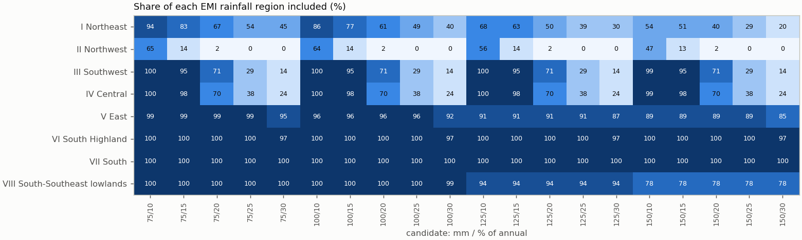
Share of each EMI rainfall region included Region Included I Northeast 94.4% II Northwest 65.1% III Southwest 100% IV Central 100% V East 98.6% VI South Highland 100% VII South 100% VIII South-Southeast lowlands 100%
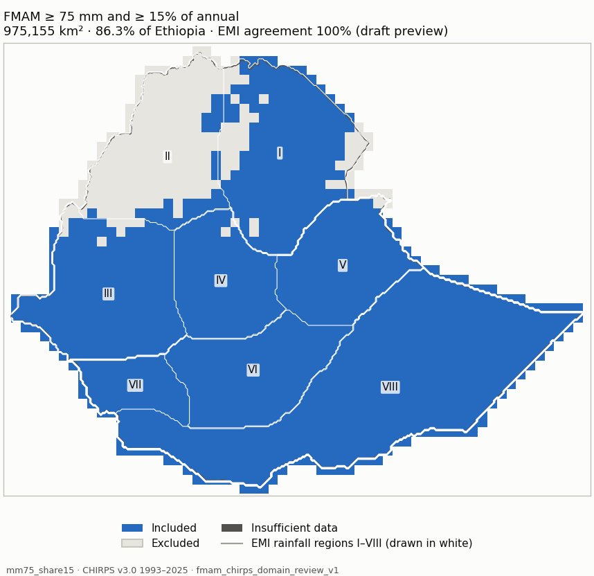
Candidate mm75_share15 (blue: included; dark grey: insufficient data) mm75_share15 Measure Value Included area 975,155 km² (86.3% of Ethiopia) Agreement with EMI-implied membership 100% (visual_only (draft preview); undecided 437,659 km²) Domain files NetCDF · GeoJSON outline Unknown area 4 km² Baseline 1981-2010 unavailable: 12 of 30 years are not in the data (1981-1992); the period is not shortened. Baseline 1991-2020 unavailable: 2 of 30 years are not in the data (1991-1992); the period is not shortened. Baseline 1996-2025 +755 km² / −9,019 km²
Share of each EMI rainfall region included Region Included I Northeast 83.2% II Northwest 14.4% III Southwest 95.2% IV Central 98.4% V East 98.6% VI South Highland 100% VII South 100% VIII South-Southeast lowlands 100%
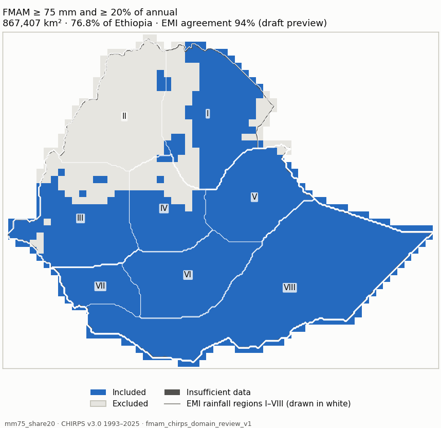
Candidate mm75_share20 (blue: included; dark grey: insufficient data) mm75_share20 Measure Value Included area 867,407 km² (76.8% of Ethiopia) Agreement with EMI-implied membership 94% (visual_only (draft preview); undecided 199,762 km²) Domain files NetCDF · GeoJSON outline Unknown area 4 km² Baseline 1981-2010 unavailable: 12 of 30 years are not in the data (1981-1992); the period is not shortened. Baseline 1991-2020 unavailable: 2 of 30 years are not in the data (1991-1992); the period is not shortened. Baseline 1996-2025 +755 km² / −8,290 km²
Share of each EMI rainfall region included Region Included I Northeast 66.8% II Northwest 2.2% III Southwest 71.1% IV Central 69.7% V East 98.6% VI South Highland 100% VII South 100% VIII South-Southeast lowlands 100%
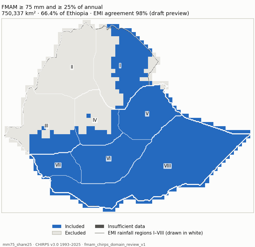
Candidate mm75_share25 (blue: included; dark grey: insufficient data) mm75_share25 Measure Value Included area 750,337 km² (66.4% of Ethiopia) Agreement with EMI-implied membership 98% (visual_only (draft preview); undecided 335,622 km²) Domain files NetCDF · GeoJSON outline Unknown area 4 km² Baseline 1981-2010 unavailable: 12 of 30 years are not in the data (1981-1992); the period is not shortened. Baseline 1991-2020 unavailable: 2 of 30 years are not in the data (1991-1992); the period is not shortened. Baseline 1996-2025 +755 km² / −2,277 km²
Share of each EMI rainfall region included Region Included I Northeast 54.1% II Northwest 0% III Southwest 29.2% IV Central 38.5% V East 98.6% VI South Highland 100% VII South 100% VIII South-Southeast lowlands 100%
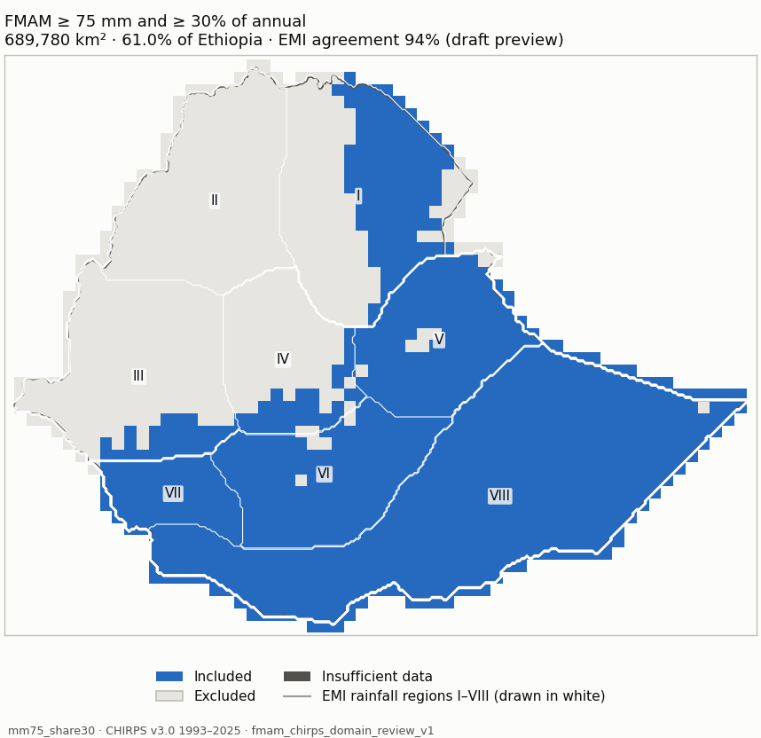
Candidate mm75_share30 (blue: included; dark grey: insufficient data) mm75_share30 Measure Value Included area 689,780 km² (61.0% of Ethiopia) Agreement with EMI-implied membership 94% (visual_only (draft preview); undecided 153,680 km²) Domain files NetCDF · GeoJSON outline Unknown area 4 km² Baseline 1981-2010 unavailable: 12 of 30 years are not in the data (1981-1992); the period is not shortened. Baseline 1991-2020 unavailable: 2 of 30 years are not in the data (1991-1992); the period is not shortened. Baseline 1996-2025 +1,518 km² / −13,644 km²
Share of each EMI rainfall region included Region Included I Northeast 44.8% II Northwest 0% III Southwest 13.6% IV Central 24.1% V East 94.7% VI South Highland 97.2% VII South 99.7% VIII South-Southeast lowlands 99.8%
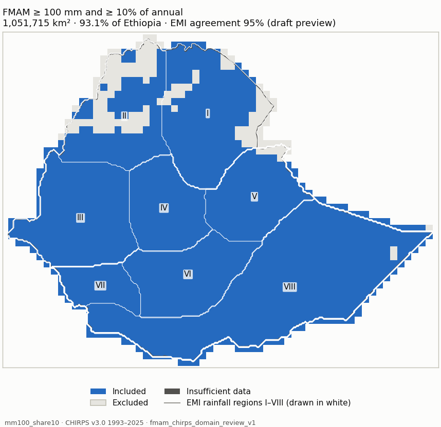
Candidate mm100_share10 (blue: included; dark grey: insufficient data) mm100_share10 Measure Value Included area 1,051,715 km² (93.1% of Ethiopia) Agreement with EMI-implied membership 95% (visual_only (draft preview); undecided 231,113 km²) Domain files NetCDF · GeoJSON outline Unknown area 4 km² Baseline 1981-2010 unavailable: 12 of 30 years are not in the data (1981-1992); the period is not shortened. Baseline 1991-2020 unavailable: 2 of 30 years are not in the data (1991-1992); the period is not shortened. Baseline 1996-2025 +0 km² / −7,512 km²
Share of each EMI rainfall region included Region Included I Northeast 85.5% II Northwest 64.5% III Southwest 100% IV Central 100% V East 95.8% VI South Highland 100% VII South 100% VIII South-Southeast lowlands 99.5%
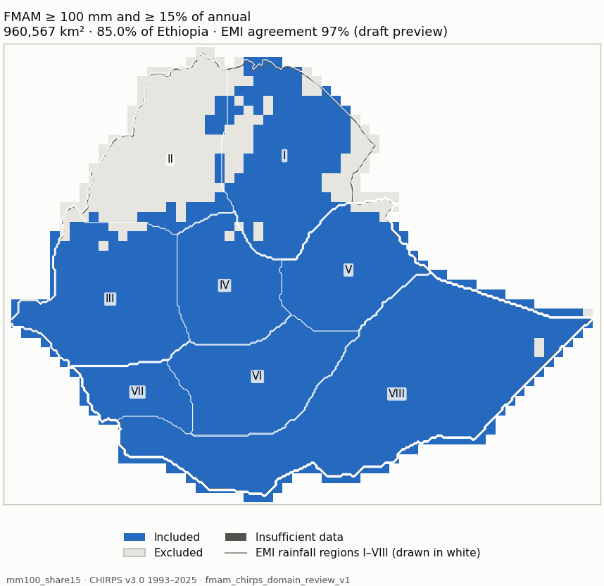
Candidate mm100_share15 (blue: included; dark grey: insufficient data) mm100_share15 Measure Value Included area 960,567 km² (85.0% of Ethiopia) Agreement with EMI-implied membership 97% (visual_only (draft preview); undecided 400,879 km²) Domain files NetCDF · GeoJSON outline Unknown area 4 km² Baseline 1981-2010 unavailable: 12 of 30 years are not in the data (1981-1992); the period is not shortened. Baseline 1991-2020 unavailable: 2 of 30 years are not in the data (1991-1992); the period is not shortened. Baseline 1996-2025 +0 km² / −10,782 km²
Share of each EMI rainfall region included Region Included I Northeast 77% II Northwest 14.4% III Southwest 95.2% IV Central 98.4% V East 95.8% VI South Highland 100% VII South 100% VIII South-Southeast lowlands 99.5%
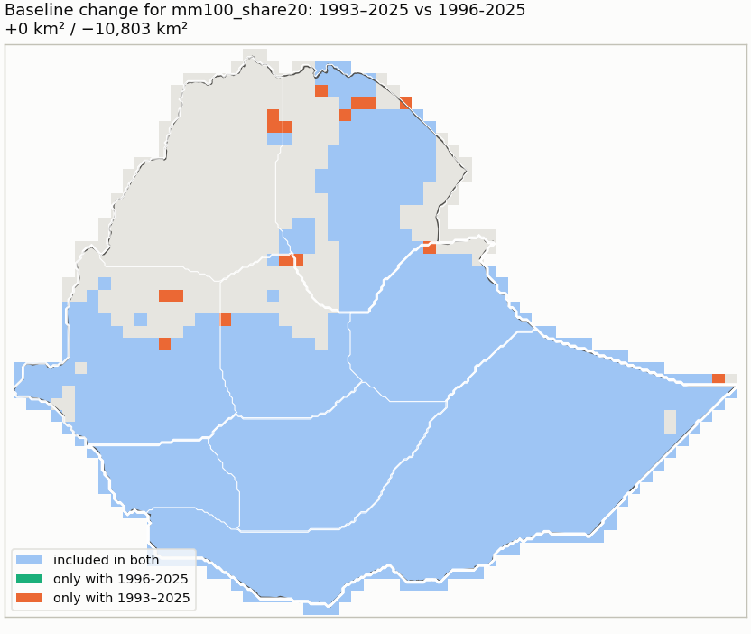
Candidate mm100_share20 (blue: included; dark grey: insufficient data) mm100_share20 Measure Value Included area 854,318 km² (75.6% of Ethiopia) Agreement with EMI-implied membership 93% (visual_only (draft preview); undecided 177,954 km²) Domain files NetCDF · GeoJSON outline Unknown area 4 km² Baseline 1981-2010 unavailable: 12 of 30 years are not in the data (1981-1992); the period is not shortened. Baseline 1991-2020 unavailable: 2 of 30 years are not in the data (1991-1992); the period is not shortened. Baseline 1996-2025 +0 km² / −10,803 km²
Share of each EMI rainfall region included Region Included I Northeast 61.4% II Northwest 2.2% III Southwest 71.1% IV Central 69.7% V East 95.8% VI South Highland 100% VII South 100% VIII South-Southeast lowlands 99.5%
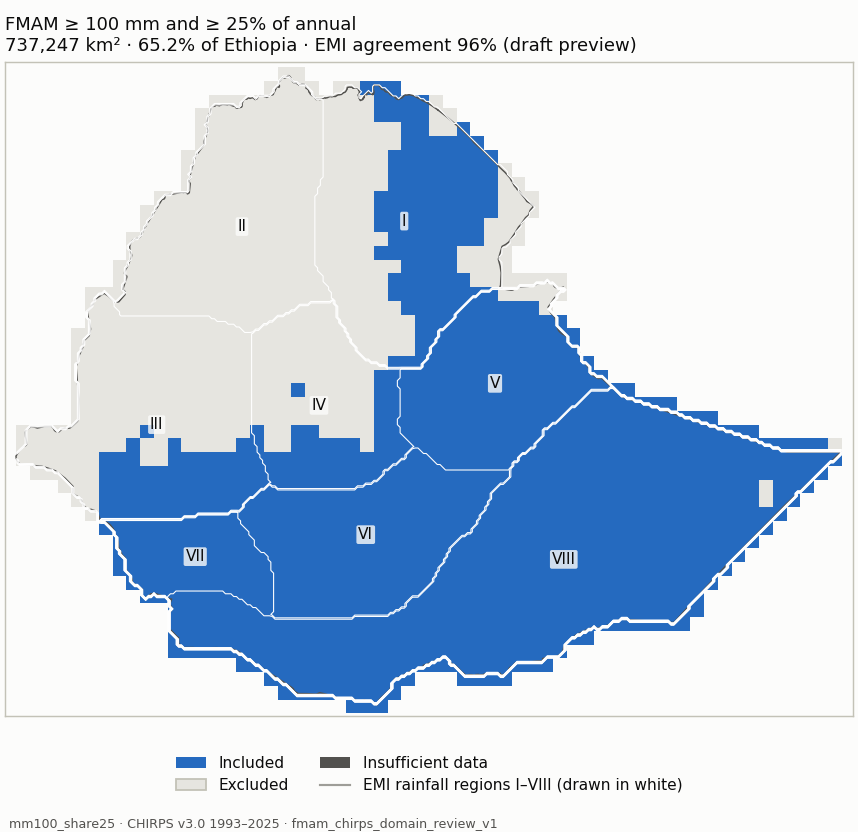
Candidate mm100_share25 (blue: included; dark grey: insufficient data) mm100_share25 Measure Value Included area 737,247 km² (65.3% of Ethiopia) Agreement with EMI-implied membership 96% (visual_only (draft preview); undecided 313,814 km²) Domain files NetCDF · GeoJSON outline Unknown area 4 km² Baseline 1981-2010 unavailable: 12 of 30 years are not in the data (1981-1992); the period is not shortened. Baseline 1991-2020 unavailable: 2 of 30 years are not in the data (1991-1992); the period is not shortened. Baseline 1996-2025 +0 km² / −4,790 km²
Share of each EMI rainfall region included Region Included I Northeast 48.8% II Northwest 0% III Southwest 29.2% IV Central 38.5% V East 95.8% VI South Highland 100% VII South 100% VIII South-Southeast lowlands 99.5%
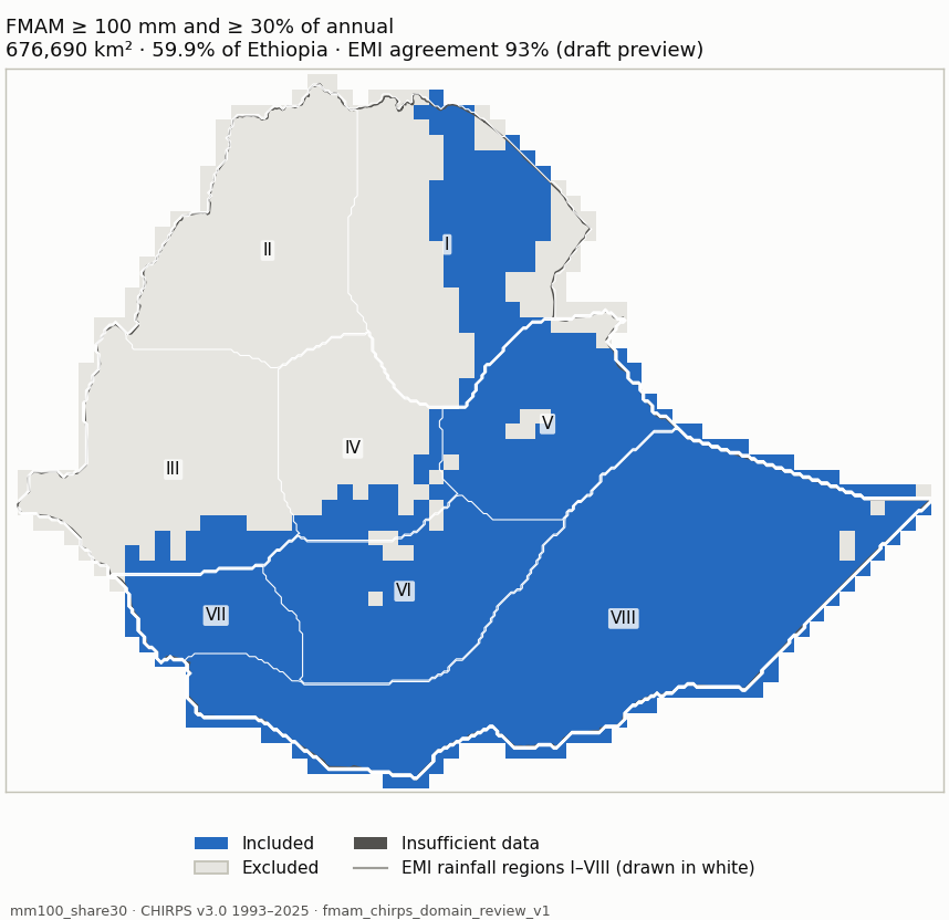
Candidate mm100_share30 (blue: included; dark grey: insufficient data) mm100_share30 Measure Value Included area 676,690 km² (59.9% of Ethiopia) Agreement with EMI-implied membership 93% (visual_only (draft preview); undecided 134,857 km²) Domain files NetCDF · GeoJSON outline Unknown area 4 km² Baseline 1981-2010 unavailable: 12 of 30 years are not in the data (1981-1992); the period is not shortened. Baseline 1991-2020 unavailable: 2 of 30 years are not in the data (1991-1992); the period is not shortened. Baseline 1996-2025 +763 km² / −16,156 km²
Share of each EMI rainfall region included Region Included I Northeast 39.5% II Northwest 0% III Southwest 13.6% IV Central 24.1% V East 91.9% VI South Highland 97.2% VII South 99.7% VIII South-Southeast lowlands 99.3%
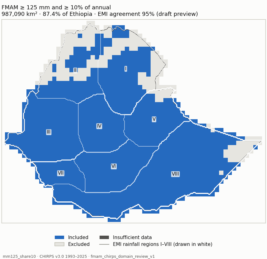
Candidate mm125_share10 (blue: included; dark grey: insufficient data) mm125_share10 Measure Value Included area 987,091 km² (87.4% of Ethiopia) Agreement with EMI-implied membership 95% (visual_only (draft preview); undecided 427,690 km²) Domain files NetCDF · GeoJSON outline Unknown area 4 km² Baseline 1981-2010 unavailable: 12 of 30 years are not in the data (1981-1992); the period is not shortened. Baseline 1991-2020 unavailable: 2 of 30 years are not in the data (1991-1992); the period is not shortened. Baseline 1996-2025 +413 km² / −7,516 km²
Share of each EMI rainfall region included Region Included I Northeast 68.2% II Northwest 56% III Southwest 100% IV Central 100% V East 91.2% VI South Highland 100% VII South 100% VIII South-Southeast lowlands 93.6%
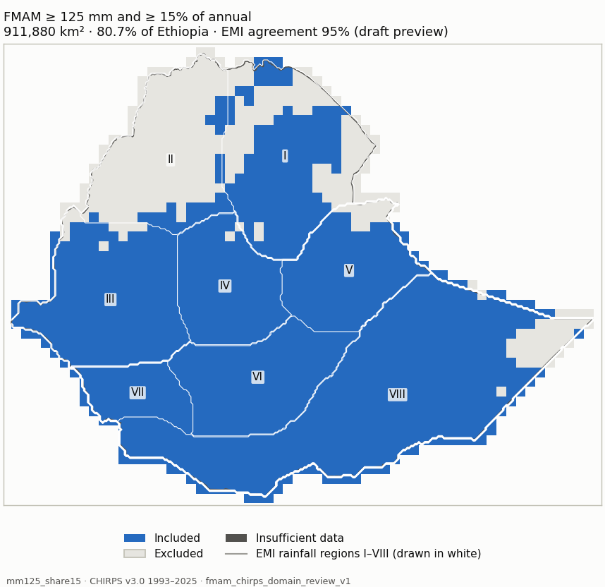
Candidate mm125_share15 (blue: included; dark grey: insufficient data) mm125_share15 Measure Value Included area 911,880 km² (80.7% of Ethiopia) Agreement with EMI-implied membership 95% (visual_only (draft preview); undecided 483,790 km²) Domain files NetCDF · GeoJSON outline Unknown area 4 km² Baseline 1981-2010 unavailable: 12 of 30 years are not in the data (1981-1992); the period is not shortened. Baseline 1991-2020 unavailable: 2 of 30 years are not in the data (1991-1992); the period is not shortened. Baseline 1996-2025 +413 km² / −10,564 km²
Share of each EMI rainfall region included Region Included I Northeast 62.8% II Northwest 13.8% III Southwest 95.2% IV Central 98.4% V East 91.2% VI South Highland 100% VII South 100% VIII South-Southeast lowlands 93.6%
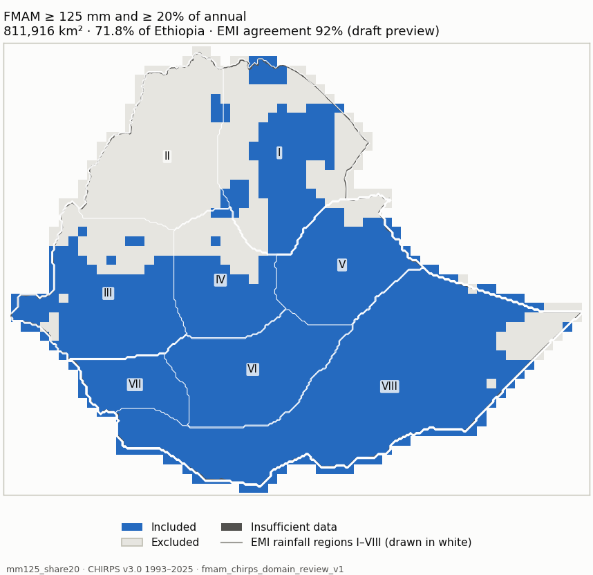
Candidate mm125_share20 (blue: included; dark grey: insufficient data) mm125_share20 Measure Value Included area 811,916 km² (71.8% of Ethiopia) Agreement with EMI-implied membership 92% (visual_only (draft preview); undecided 260,865 km²) Domain files NetCDF · GeoJSON outline Unknown area 4 km² Baseline 1981-2010 unavailable: 12 of 30 years are not in the data (1981-1992); the period is not shortened. Baseline 1991-2020 unavailable: 2 of 30 years are not in the data (1991-1992); the period is not shortened. Baseline 1996-2025 +413 km² / −11,302 km²
Share of each EMI rainfall region included Region Included I Northeast 50.5% II Northwest 2.2% III Southwest 71.1% IV Central 69.7% V East 91.2% VI South Highland 100% VII South 100% VIII South-Southeast lowlands 93.6%
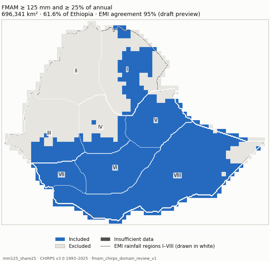
Candidate mm125_share25 (blue: included; dark grey: insufficient data) mm125_share25 Measure Value Included area 696,341 km² (61.6% of Ethiopia) Agreement with EMI-implied membership 95% (visual_only (draft preview); undecided 380,183 km²) Domain files NetCDF · GeoJSON outline Unknown area 4 km² Baseline 1981-2010 unavailable: 12 of 30 years are not in the data (1981-1992); the period is not shortened. Baseline 1991-2020 unavailable: 2 of 30 years are not in the data (1991-1992); the period is not shortened. Baseline 1996-2025 +413 km² / −6,037 km²
Share of each EMI rainfall region included Region Included I Northeast 38.8% II Northwest 0% III Southwest 29.2% IV Central 38.5% V East 91.2% VI South Highland 100% VII South 100% VIII South-Southeast lowlands 93.6%
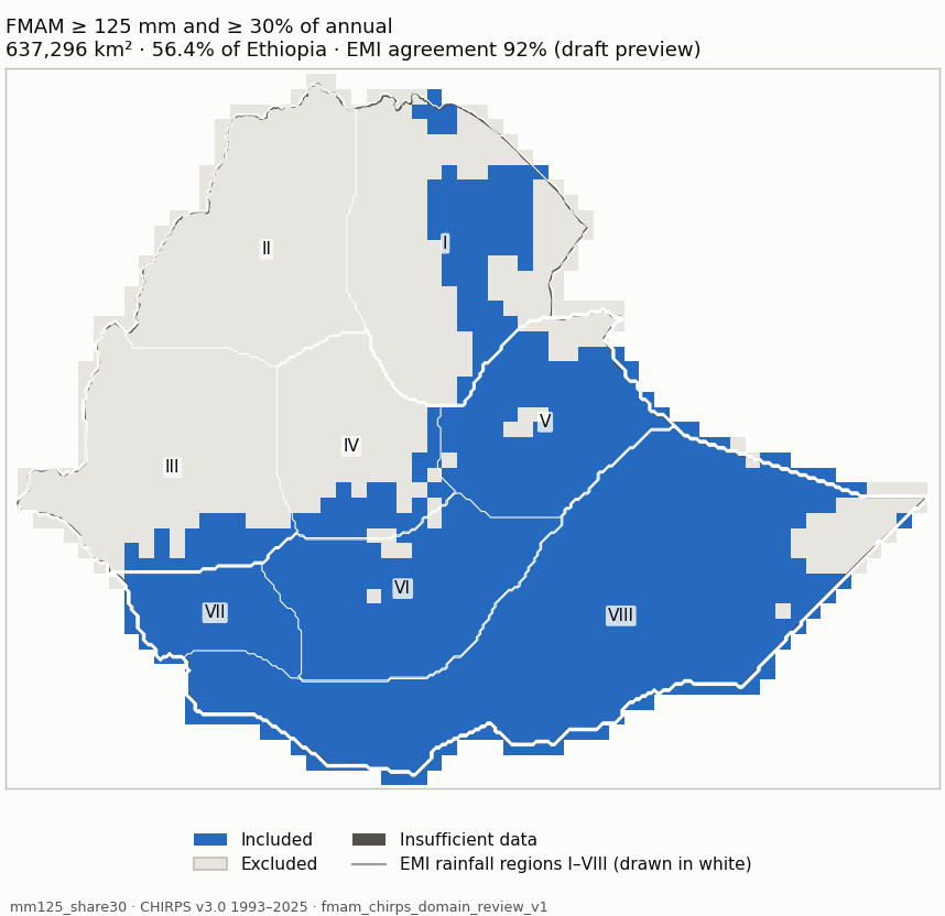
Candidate mm125_share30 (blue: included; dark grey: insufficient data) mm125_share30 Measure Value Included area 637,296 km² (56.4% of Ethiopia) Agreement with EMI-implied membership 92% (visual_only (draft preview); undecided 201,227 km²) Domain files NetCDF · GeoJSON outline Unknown area 4 km² Baseline 1981-2010 unavailable: 12 of 30 years are not in the data (1981-1992); the period is not shortened. Baseline 1991-2020 unavailable: 2 of 30 years are not in the data (1991-1992); the period is not shortened. Baseline 1996-2025 +1,176 km² / −17,404 km²
Share of each EMI rainfall region included Region Included I Northeast 29.9% II Northwest 0% III Southwest 13.6% IV Central 24.1% V East 87.3% VI South Highland 97.2% VII South 99.7% VIII South-Southeast lowlands 93.6%
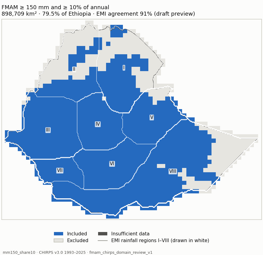
Candidate mm150_share10 (blue: included; dark grey: insufficient data) mm150_share10 Measure Value Included area 898,709 km² (79.5% of Ethiopia) Agreement with EMI-implied membership 91% (visual_only (draft preview); undecided 427,690 km²) Domain files NetCDF · GeoJSON outline Unknown area 4 km² Baseline 1981-2010 unavailable: 12 of 30 years are not in the data (1981-1992); the period is not shortened. Baseline 1991-2020 unavailable: 2 of 30 years are not in the data (1991-1992); the period is not shortened. Baseline 1996-2025 +1,281 km² / −7,721 km²
Share of each EMI rainfall region included Region Included I Northeast 54.5% II Northwest 47.1% III Southwest 99.4% IV Central 99.2% V East 88.8% VI South Highland 100% VII South 100% VIII South-Southeast lowlands 78.5%
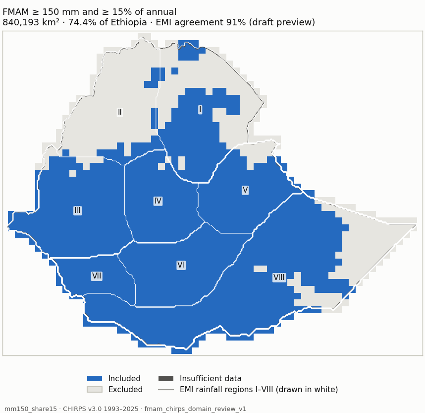
Candidate mm150_share15 (blue: included; dark grey: insufficient data) mm150_share15 Measure Value Included area 840,193 km² (74.4% of Ethiopia) Agreement with EMI-implied membership 91% (visual_only (draft preview); undecided 483,790 km²) Domain files NetCDF · GeoJSON outline Unknown area 4 km² Baseline 1981-2010 unavailable: 12 of 30 years are not in the data (1981-1992); the period is not shortened. Baseline 1991-2020 unavailable: 2 of 30 years are not in the data (1991-1992); the period is not shortened. Baseline 1996-2025 +1,281 km² / −10,764 km²
Share of each EMI rainfall region included Region Included I Northeast 51.3% II Northwest 13.3% III Southwest 95.2% IV Central 98.4% V East 88.8% VI South Highland 100% VII South 100% VIII South-Southeast lowlands 78.5%
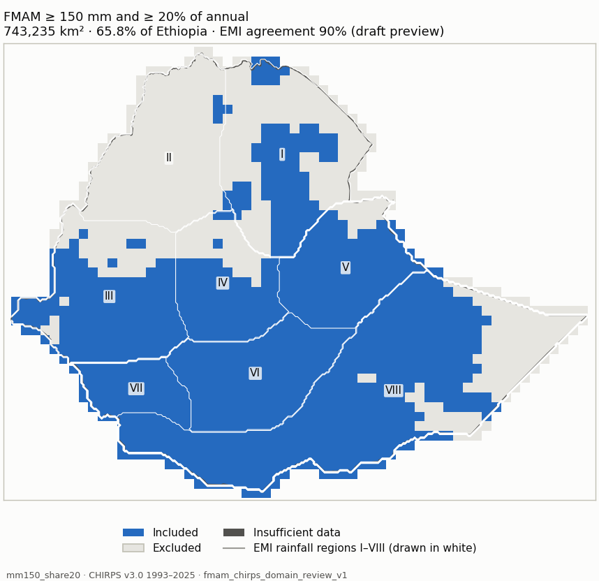
Candidate mm150_share20 (blue: included; dark grey: insufficient data) mm150_share20 Measure Value Included area 743,235 km² (65.8% of Ethiopia) Agreement with EMI-implied membership 90% (visual_only (draft preview); undecided 260,865 km²) Domain files NetCDF · GeoJSON outline Unknown area 4 km² Baseline 1981-2010 unavailable: 12 of 30 years are not in the data (1981-1992); the period is not shortened. Baseline 1991-2020 unavailable: 2 of 30 years are not in the data (1991-1992); the period is not shortened. Baseline 1996-2025 +1,281 km² / −10,764 km²
Share of each EMI rainfall region included Region Included I Northeast 40.4% II Northwest 2.2% III Southwest 71.1% IV Central 69.7% V East 88.8% VI South Highland 100% VII South 100% VIII South-Southeast lowlands 78.5%
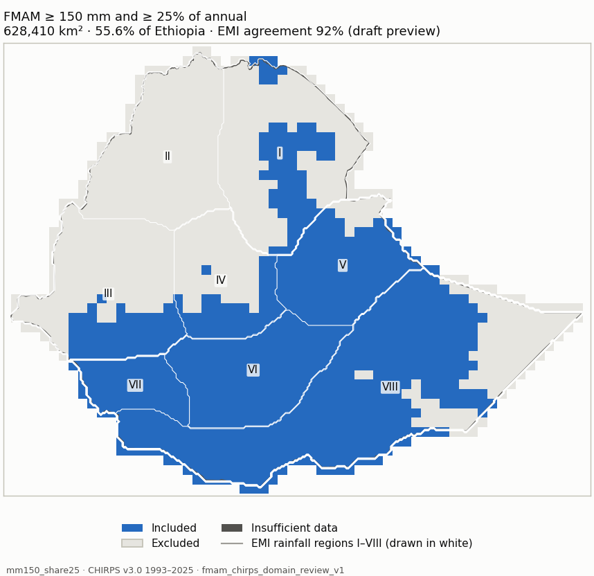
Candidate mm150_share25 (blue: included; dark grey: insufficient data) mm150_share25 Measure Value Included area 628,410 km² (55.6% of Ethiopia) Agreement with EMI-implied membership 92% (visual_only (draft preview); undecided 380,183 km²) Domain files NetCDF · GeoJSON outline Unknown area 4 km² Baseline 1981-2010 unavailable: 12 of 30 years are not in the data (1981-1992); the period is not shortened. Baseline 1991-2020 unavailable: 2 of 30 years are not in the data (1991-1992); the period is not shortened. Baseline 1996-2025 +1,281 km² / −4,828 km²
Share of each EMI rainfall region included Region Included I Northeast 29.1% II Northwest 0% III Southwest 29.2% IV Central 38.5% V East 88.8% VI South Highland 100% VII South 100% VIII South-Southeast lowlands 78.5%
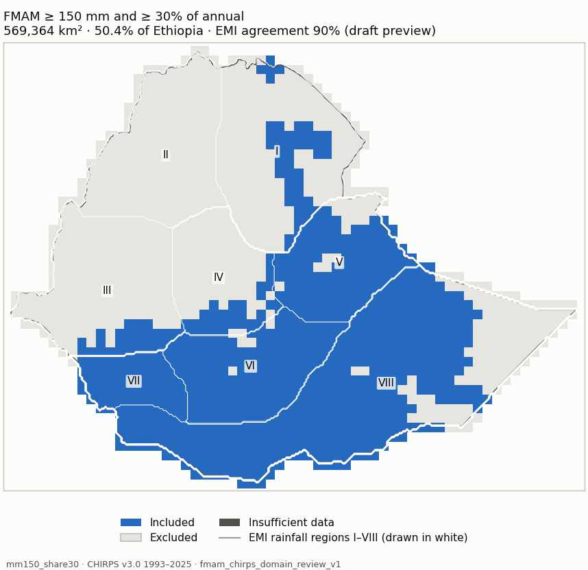
Candidate mm150_share30 (blue: included; dark grey: insufficient data) mm150_share30 Measure Value Included area 569,364 km² (50.4% of Ethiopia) Agreement with EMI-implied membership 90% (visual_only (draft preview); undecided 201,227 km²) Domain files NetCDF · GeoJSON outline Unknown area 4 km² Baseline 1981-2010 unavailable: 12 of 30 years are not in the data (1981-1992); the period is not shortened. Baseline 1991-2020 unavailable: 2 of 30 years are not in the data (1991-1992); the period is not shortened. Baseline 1996-2025 +2,044 km² / −15,090 km²
Share of each EMI rainfall region included Region Included I Northeast 20.3% II Northwest 0% III Southwest 13.6% IV Central 24.1% V East 84.9% VI South Highland 97.2% VII South 99.7% VIII South-Southeast lowlands 78.5%
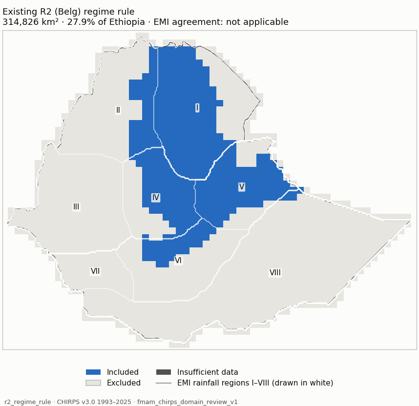
r2_regime_rule (blue: included; dark grey: insufficient data) r2_regime_rule Measure Value Included area 314,826 km² (27.9% of Ethiopia) Agreement with EMI-implied membership Regime membership is not an amount/share threshold, so EMI classes imply no membership for it. Domain files NetCDF · GeoJSON outline
Share of each EMI rainfall region included Region Included I Northeast 72.6% II Northwest 23.7% III Southwest 0% IV Central 63.2% V East 74.9% VI South Highland 23.7% VII South 0% VIII South-Southeast lowlands 0.8%
share40_mm80 (blue: included; dark grey: insufficient data) share40_mm80 Measure Value Included area 441,889 km² (39.1% of Ethiopia) Agreement with EMI-implied membership 94% (visual_only (draft preview); undecided 94,982 km²) Domain files NetCDF · GeoJSON outline
Share of each EMI rainfall region included Region Included I Northeast 10.6% II Northwest 0% III Southwest 0% IV Central 0% V East 21.3% VI South Highland 57.4% VII South 36.4% VIII South-Southeast lowlands 98.4%
wettest_mm80 (blue: included; dark grey: insufficient data) wettest_mm80 Measure Value Included area 409,911 km² (36.3% of Ethiopia) Agreement with EMI-implied membership Wettest-season membership compares FMAM with JJAS and ONDJ; the EMI maps give no JJAS/ONDJ amounts. Domain files NetCDF · GeoJSON outline
Share of each EMI rainfall region included Region Included I Northeast 6.1% II Northwest 0% III Southwest 0% IV Central 0% V East 16.4% VI South Highland 62.3% VII South 61.6% VIII South-Southeast lowlands 87.5%
belg_emi_view (blue: included; dark grey: insufficient data) belg_emi_view Measure Value Included area 804,940 km² (71.2% of Ethiopia) Agreement with EMI-implied membership 92% (visual_only (draft preview); undecided 177,954 km²) Domain files NetCDF · GeoJSON outline
Share of each EMI rainfall region included Region Included I Northeast 50.5% II Northwest 1.1% III Southwest 72.2% IV Central 76.1% V East 87.4% VI South Highland 100% VII South 98.5% VIII South-Southeast lowlands 90.9%
Named comparisons Rule Share of Ethiopia Agreement with EMI-implied membership Files Existing R2 (Belg) regime rule: R2 membership, FMAM >= 80 mm, patches < 3 cells removed 27.9% Regime membership is not an amount/share threshold, so EMI classes imply no membership for it. NetCDF · GeoJSON 40% contribution rule: FMAM >= 40% of annual and >= 80 mm (no cleanup) 39.1% 94% NetCDF · GeoJSON Wettest-season rule: FMAM wetter than JJAS and ONDJ, >= 80 mm (no cleanup) 36.3% Wettest-season membership compares FMAM with JJAS and ONDJ; the EMI maps give no JJAS/ONDJ amounts. NetCDF · GeoJSON Previous FMAM site view (FMAM_belg_emi_domain, used until 2026-10-10): >= 20% and >= 100 mm from the 365-day cycle, patches < 3 cells removed 71.2% 92% NetCDF · GeoJSON
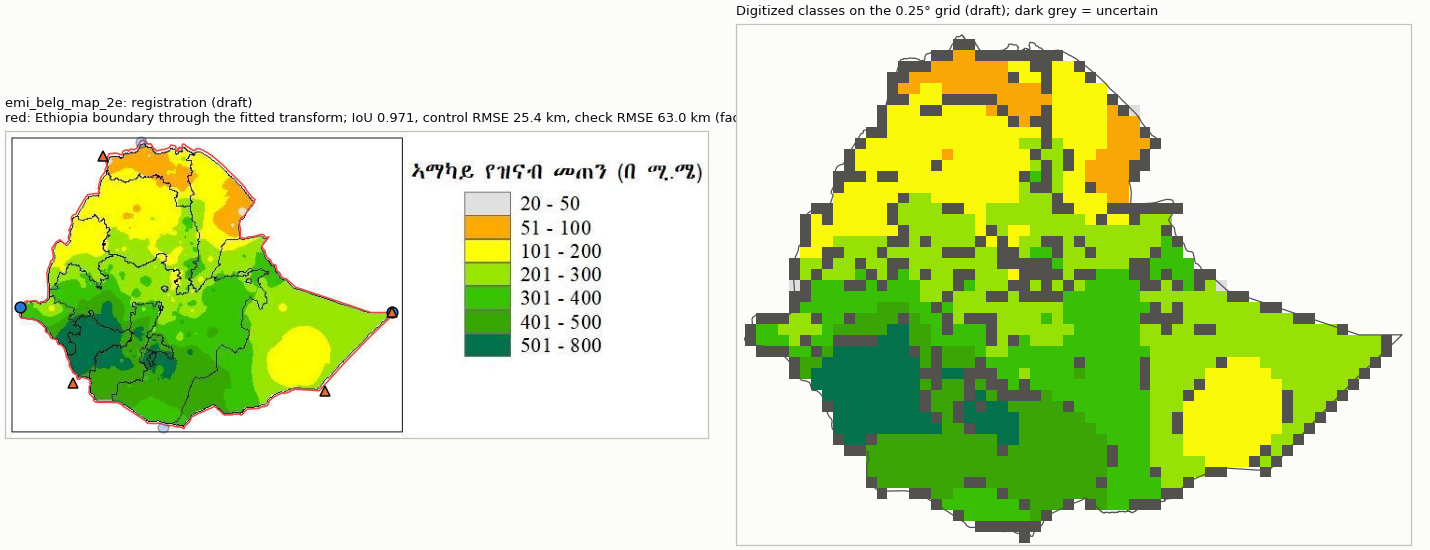
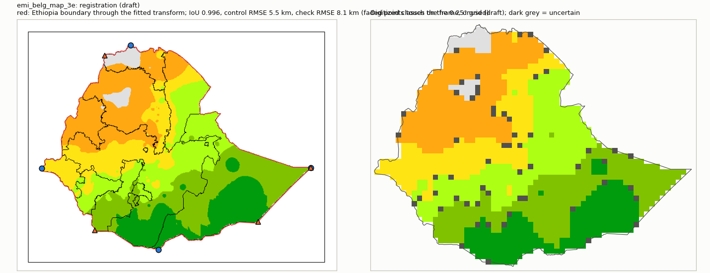
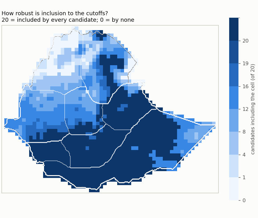
Named comparisons side by side All threshold candidates (rows: rainfall cutoff; columns: share cutoff) Included share of Ethiopia for each candidate How many candidates include each cell Regional inclusion by candidate Agreement of CHIRPS with the EMI classes Reference Mode Exact class Within one class CHIRPS wetter / drier Outside the class interval (median / 90th pct) Comparable / uncertain area emi_belg_map_2e visual only (unreviewed preview) 56% 94% 19% / 26% 0.0 / 82.0 mm 918,469 km² / 201,785 km² emi_belg_map_3e visual only (unreviewed preview) 71% 97% 18% / 11% 0.0 / 4.8 pp 1,069,585 km² / 40,026 km²
Largest changes between neighbouring cutoffs From To Changed Area switching mm75_share20 mm75_share25 annual share percent 117,071 km² mm100_share20 mm100_share25 annual share percent 117,071 km² mm125_share20 mm125_share25 annual share percent 115,575 km² mm150_share20 mm150_share25 annual share percent 114,825 km² mm75_share15 mm75_share20 annual share percent 107,748 km² mm100_share15 mm100_share20 annual share percent 106,249 km²
Baseline sensitivity of mm100_share20 Candidates nested (raising a cutoff never adds a cell): yes. Dataset sensitivity: not assessed (CHIRPS only).