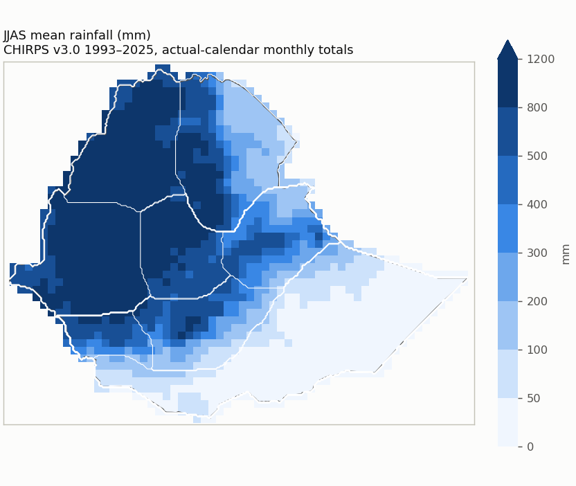
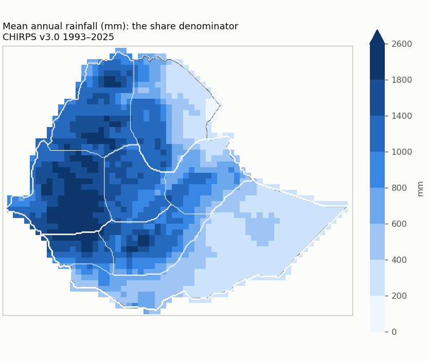
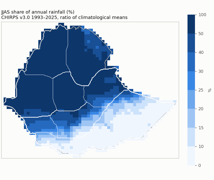
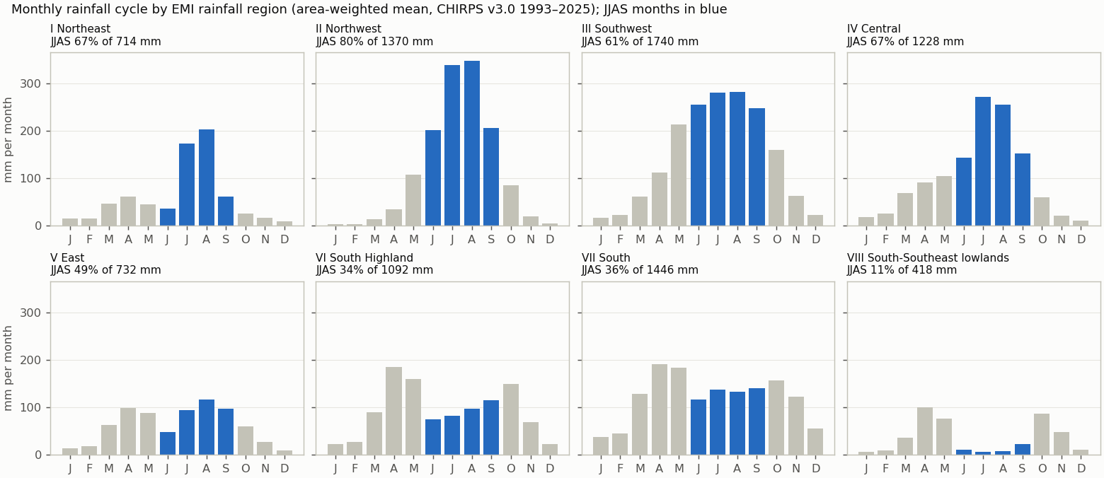
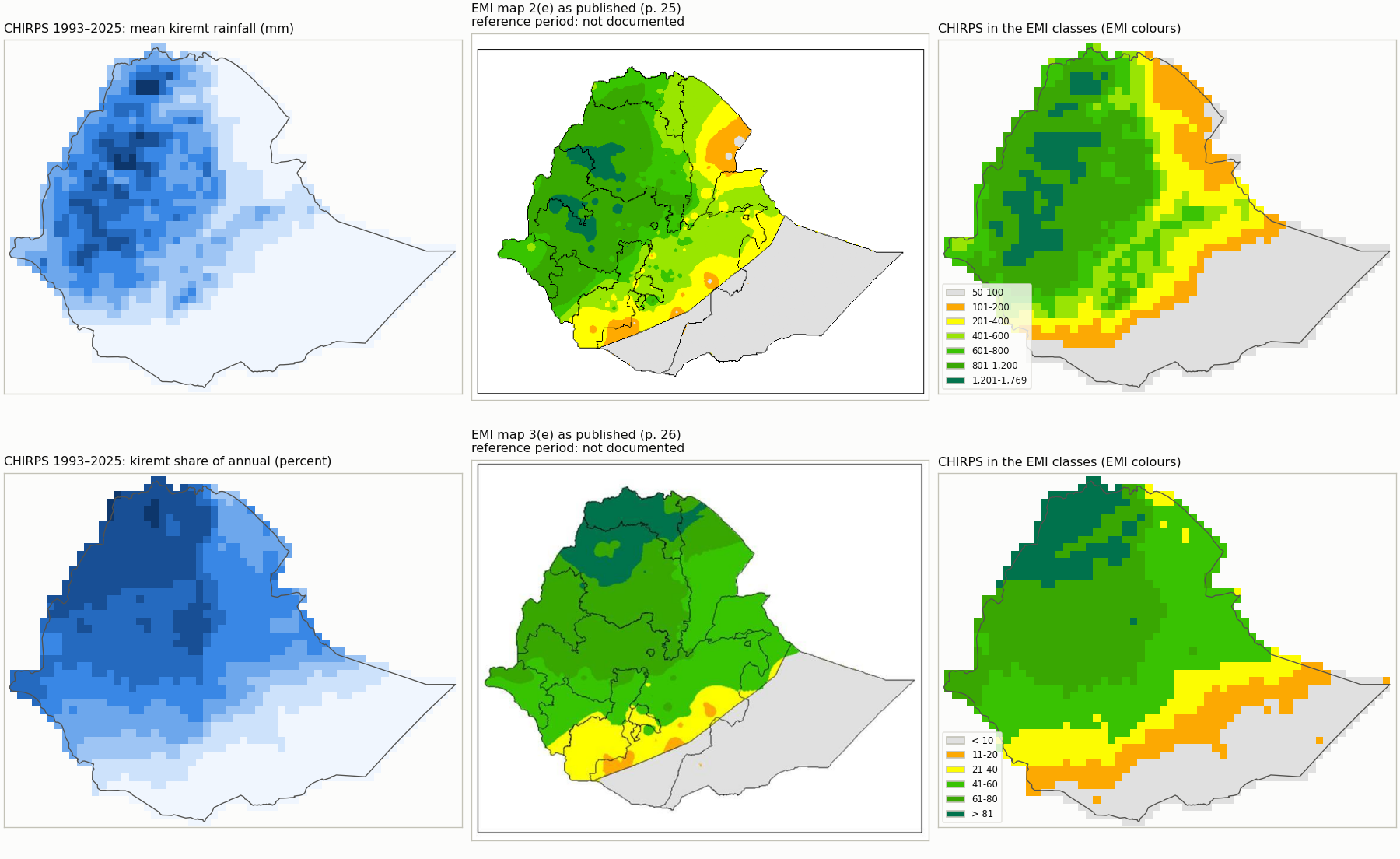
Where does a season's rain matter? Before a forecast domain is chosen, this review computes the observed climatology (seasonal
total, annual total and the season's share), compares it with EMI's published long-term maps, and tests every combination of rainfall
and annual-share cutoffs. Cutoffs are chosen for what the domain means climatologically, never to improve a forecast score.
Evidence only: no candidate has been selected for JJAS, so the forecast products keep their current domain (JJAS R1+R2 rainfall domain).
JJAS climatology from CHIRPS v3.0 1993–2025 · built 2026-10-10 · Full review report
No candidate has been selected yet. The review shows the evidence; a domain is exported to the forecast products only after an explicit selection.
Climatology References Candidate domains Assessment
JJAS rainfall ≥ 100 mm ≥ 200 mm ≥ 400 mm ≥ 600 mm
Share of annual ≥ 20% ≥ 40% ≥ 60% ≥ 80%
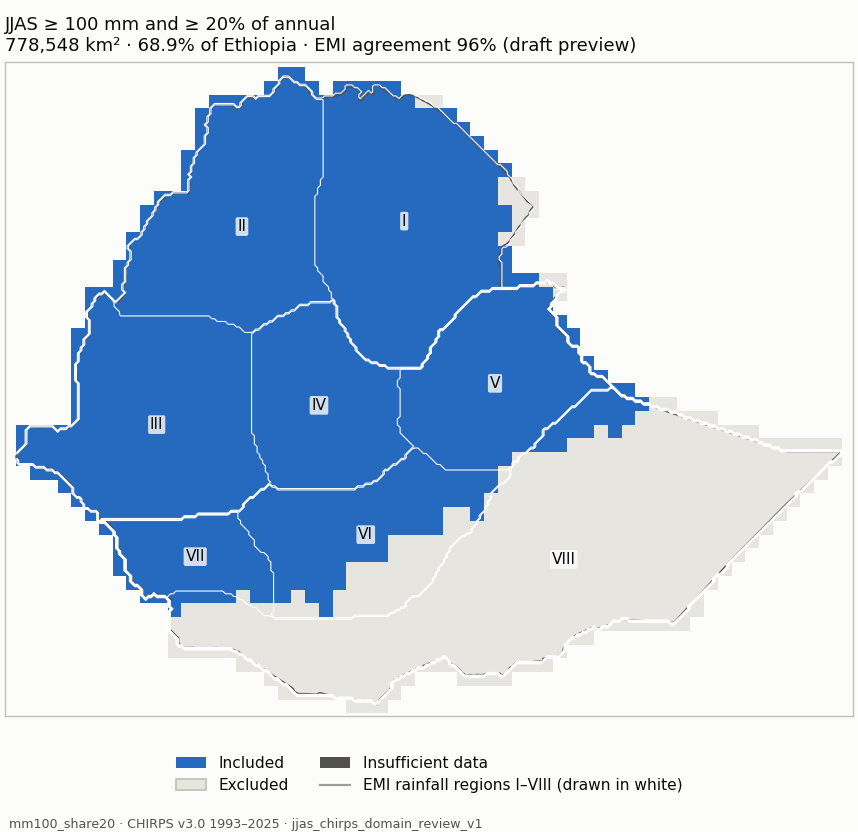
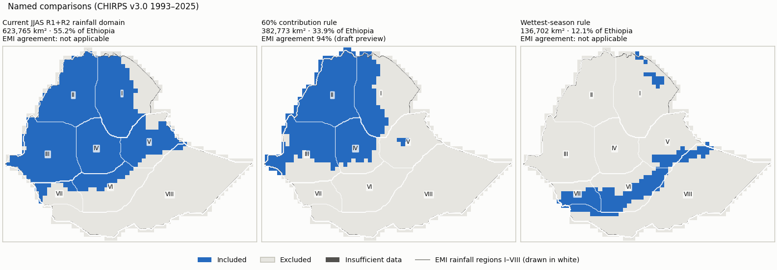
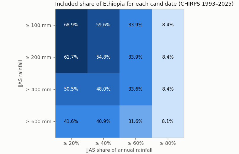
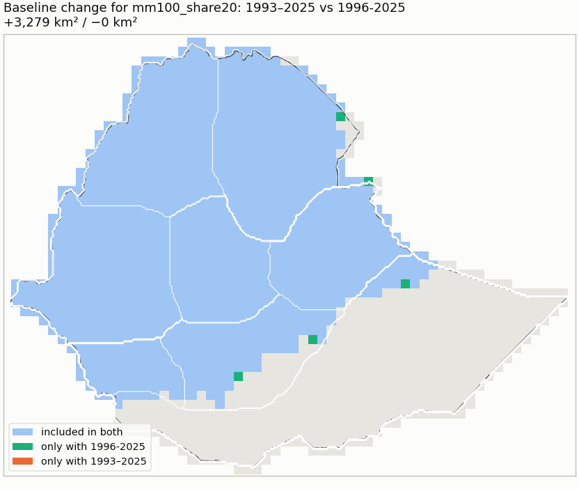
Comparison — threshold candidates — Current JJAS R1+R2 rainfall domain: R1/R2 membership, JJAS >= 120 mm and >= 20% of annual 60% contribution rule: JJAS >= 60% of annual and >= 200 mm (no cleanup) Wettest-season rule: JJAS wetter than FMAM and ONDJ, >= 100 mm (no cleanup) Candidate mm100_share20 (blue: included; dark grey: insufficient data) mm100_share20 Measure Value Included area 778,548 km² (68.9% of Ethiopia) Agreement with EMI-implied membership 96% (visual_only (draft preview); undecided 124,225 km²) Domain files NetCDF · GeoJSON outline Unknown area 4 km² Baseline 1981-2010 unavailable: 12 of 30 years are not in the data (1981-1992); the period is not shortened. Baseline 1991-2020 unavailable: 2 of 30 years are not in the data (1991-1992); the period is not shortened. Baseline 1996-2025 +3,279 km² / −0 km²
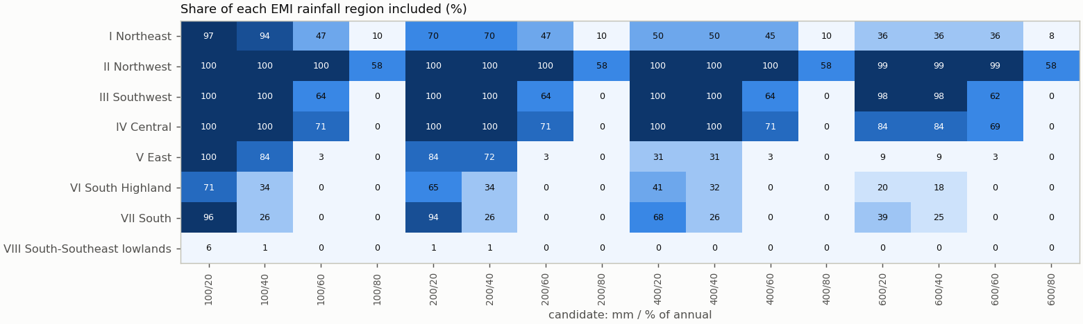
Share of each EMI rainfall region included Region Included I Northeast 97% II Northwest 100% III Southwest 100% IV Central 100% V East 99.5% VI South Highland 70.6% VII South 96.5% VIII South-Southeast lowlands 5.5%
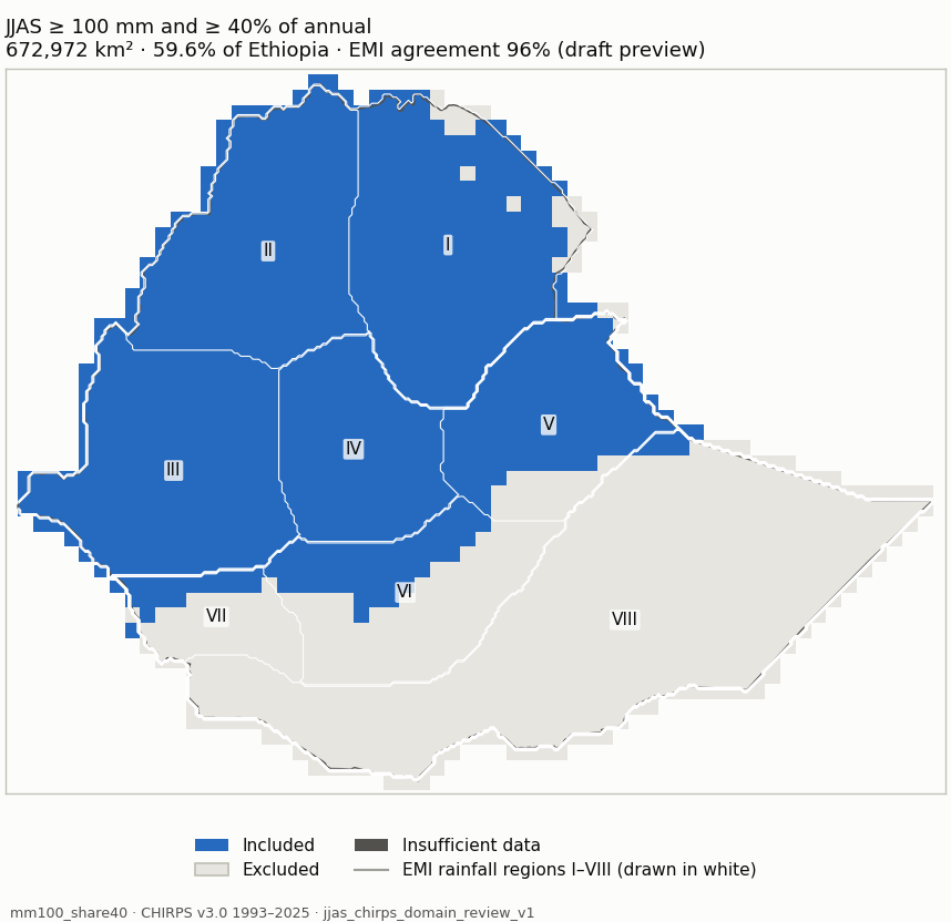
Candidate mm100_share40 (blue: included; dark grey: insufficient data) mm100_share40 Measure Value Included area 672,972 km² (59.6% of Ethiopia) Agreement with EMI-implied membership 96% (visual_only (draft preview); undecided 113,529 km²) Domain files NetCDF · GeoJSON outline Unknown area 4 km² Baseline 1981-2010 unavailable: 12 of 30 years are not in the data (1981-1992); the period is not shortened. Baseline 1991-2020 unavailable: 2 of 30 years are not in the data (1991-1992); the period is not shortened. Baseline 1996-2025 +5,552 km² / −0 km²
Share of each EMI rainfall region included Region Included I Northeast 94.4% II Northwest 100% III Southwest 100% IV Central 100% V East 83.9% VI South Highland 33.5% VII South 25.8% VIII South-Southeast lowlands 1%
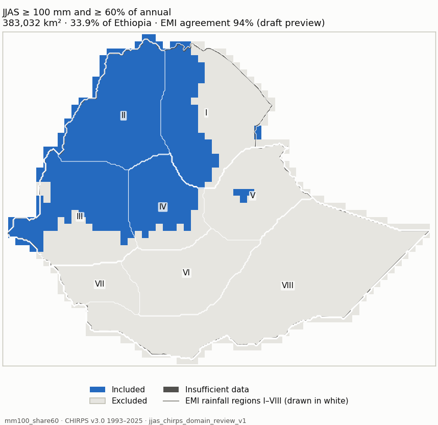
Candidate mm100_share60 (blue: included; dark grey: insufficient data) mm100_share60 Measure Value Included area 383,032 km² (33.9% of Ethiopia) Agreement with EMI-implied membership 94% (visual_only (draft preview); undecided 89,598 km²) Domain files NetCDF · GeoJSON outline Unknown area 4 km² Baseline 1981-2010 unavailable: 12 of 30 years are not in the data (1981-1992); the period is not shortened. Baseline 1991-2020 unavailable: 2 of 30 years are not in the data (1991-1992); the period is not shortened. Baseline 1996-2025 +3,029 km² / −0 km²
Share of each EMI rainfall region included Region Included I Northeast 47.3% II Northwest 100% III Southwest 64.4% IV Central 71.1% V East 3.1% VI South Highland 0% VII South 0% VIII South-Southeast lowlands 0%
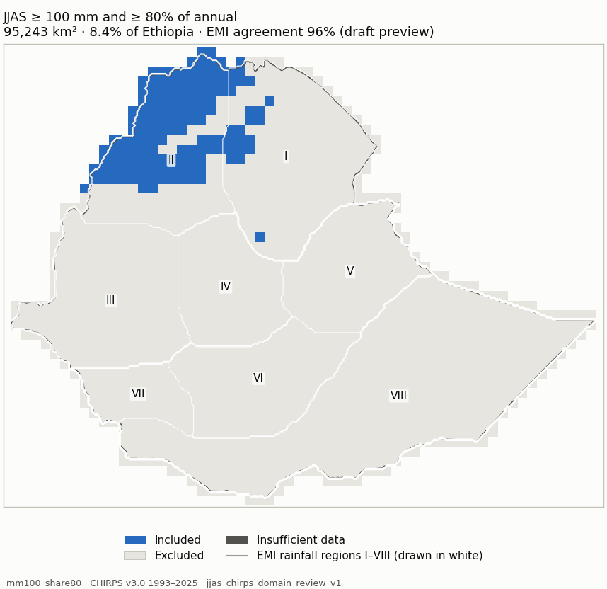
Candidate mm100_share80 (blue: included; dark grey: insufficient data) mm100_share80 Measure Value Included area 95,243 km² (8.4% of Ethiopia) Agreement with EMI-implied membership 96% (visual_only (draft preview); undecided 69,908 km²) Domain files NetCDF · GeoJSON outline Unknown area 4 km² Baseline 1981-2010 unavailable: 12 of 30 years are not in the data (1981-1992); the period is not shortened. Baseline 1991-2020 unavailable: 2 of 30 years are not in the data (1991-1992); the period is not shortened. Baseline 1996-2025 +2,248 km² / −1,502 km²
Share of each EMI rainfall region included Region Included I Northeast 9.8% II Northwest 57.9% III Southwest 0% IV Central 0% V East 0% VI South Highland 0% VII South 0% VIII South-Southeast lowlands 0%
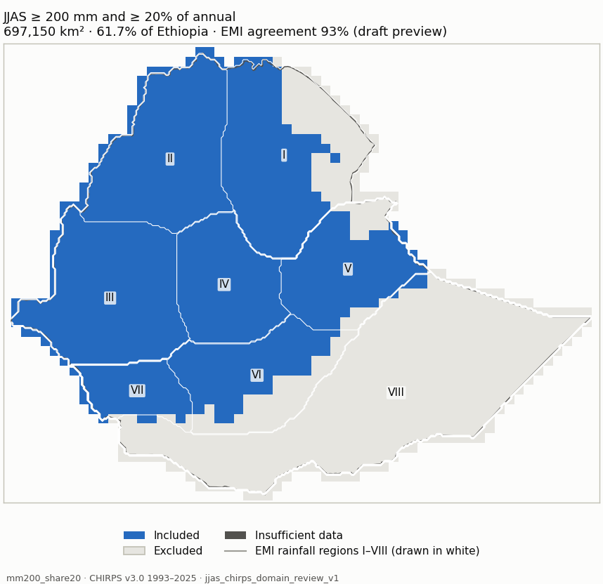
Candidate mm200_share20 (blue: included; dark grey: insufficient data) mm200_share20 Measure Value Included area 697,150 km² (61.7% of Ethiopia) Agreement with EMI-implied membership 93% (visual_only (draft preview); undecided 122,695 km²) Domain files NetCDF · GeoJSON outline Unknown area 4 km² Baseline 1981-2010 unavailable: 12 of 30 years are not in the data (1981-1992); the period is not shortened. Baseline 1991-2020 unavailable: 2 of 30 years are not in the data (1991-1992); the period is not shortened. Baseline 1996-2025 +2,282 km² / −0 km²
Share of each EMI rainfall region included Region Included I Northeast 69.9% II Northwest 100% III Southwest 100% IV Central 100% V East 84.1% VI South Highland 65% VII South 94% VIII South-Southeast lowlands 1.2%
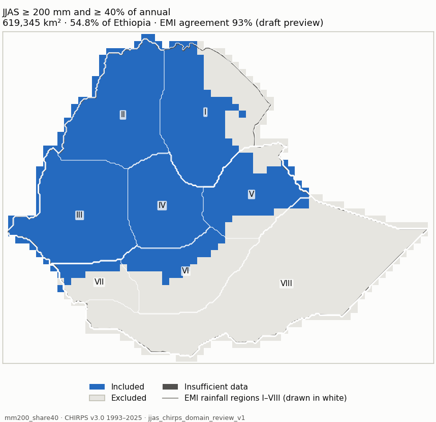
Candidate mm200_share40 (blue: included; dark grey: insufficient data) mm200_share40 Measure Value Included area 619,345 km² (54.8% of Ethiopia) Agreement with EMI-implied membership 93% (visual_only (draft preview); undecided 111,999 km²) Domain files NetCDF · GeoJSON outline Unknown area 4 km² Baseline 1981-2010 unavailable: 12 of 30 years are not in the data (1981-1992); the period is not shortened. Baseline 1991-2020 unavailable: 2 of 30 years are not in the data (1991-1992); the period is not shortened. Baseline 1996-2025 +4,565 km² / −0 km²
Share of each EMI rainfall region included Region Included I Northeast 69.5% II Northwest 100% III Southwest 100% IV Central 100% V East 72.4% VI South Highland 33.5% VII South 25.8% VIII South-Southeast lowlands 0.7%
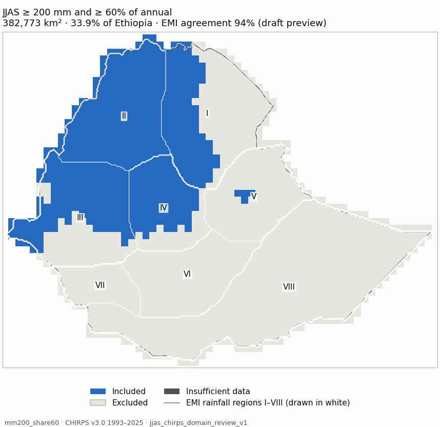
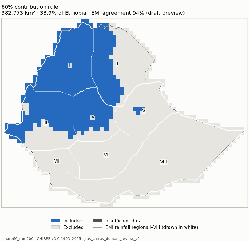
Candidate mm200_share60 (blue: included; dark grey: insufficient data) mm200_share60 Measure Value Included area 382,773 km² (33.9% of Ethiopia) Agreement with EMI-implied membership 94% (visual_only (draft preview); undecided 88,068 km²) Domain files NetCDF · GeoJSON outline Unknown area 4 km² Baseline 1981-2010 unavailable: 12 of 30 years are not in the data (1981-1992); the period is not shortened. Baseline 1991-2020 unavailable: 2 of 30 years are not in the data (1991-1992); the period is not shortened. Baseline 1996-2025 +3,029 km² / −0 km²
Share of each EMI rainfall region included Region Included I Northeast 47.1% II Northwest 100% III Southwest 64.4% IV Central 71.1% V East 3.1% VI South Highland 0% VII South 0% VIII South-Southeast lowlands 0%
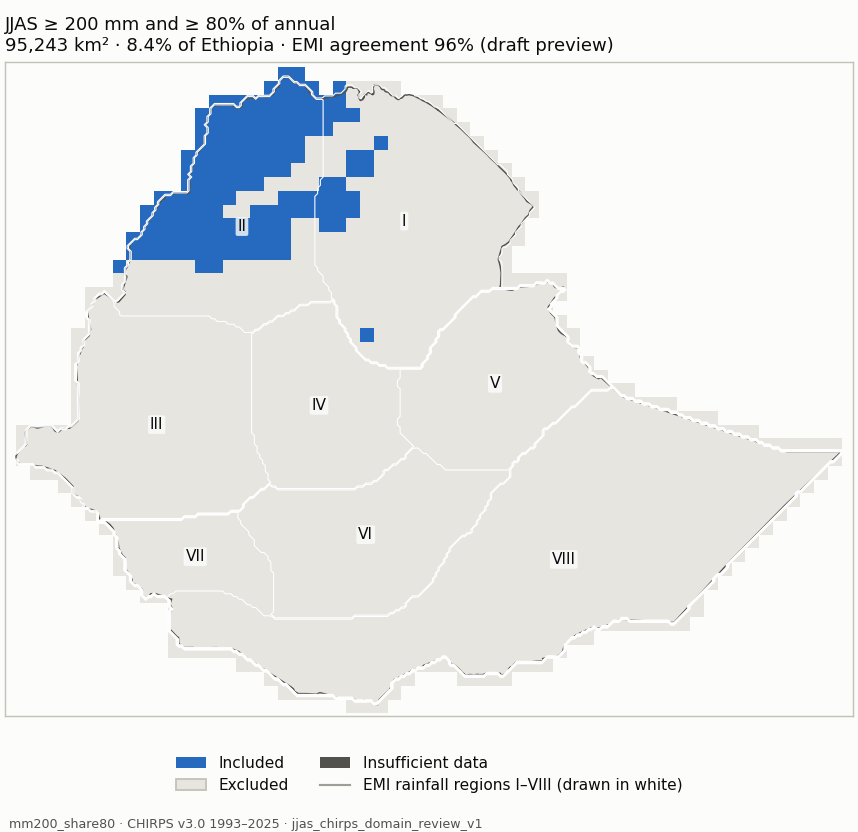
Candidate mm200_share80 (blue: included; dark grey: insufficient data) mm200_share80 Measure Value Included area 95,243 km² (8.4% of Ethiopia) Agreement with EMI-implied membership 96% (visual_only (draft preview); undecided 68,378 km²) Domain files NetCDF · GeoJSON outline Unknown area 4 km² Baseline 1981-2010 unavailable: 12 of 30 years are not in the data (1981-1992); the period is not shortened. Baseline 1991-2020 unavailable: 2 of 30 years are not in the data (1991-1992); the period is not shortened. Baseline 1996-2025 +2,248 km² / −1,502 km²
Share of each EMI rainfall region included Region Included I Northeast 9.8% II Northwest 57.9% III Southwest 0% IV Central 0% V East 0% VI South Highland 0% VII South 0% VIII South-Southeast lowlands 0%
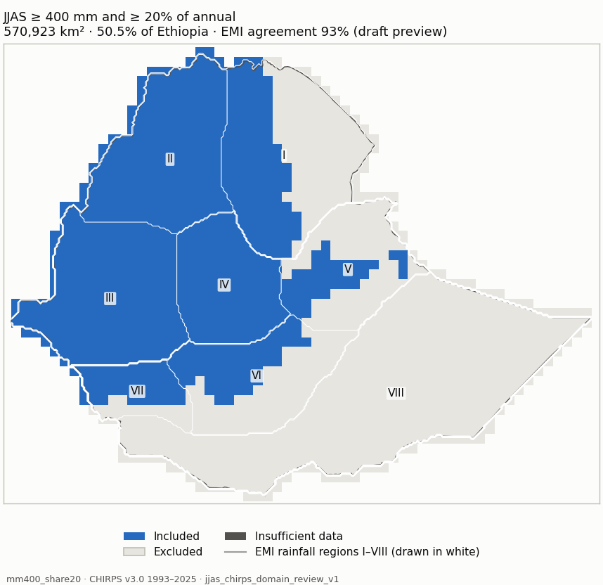
Candidate mm400_share20 (blue: included; dark grey: insufficient data) mm400_share20 Measure Value Included area 570,923 km² (50.5% of Ethiopia) Agreement with EMI-implied membership 93% (visual_only (draft preview); undecided 120,416 km²) Domain files NetCDF · GeoJSON outline Unknown area 4 km² Baseline 1981-2010 unavailable: 12 of 30 years are not in the data (1981-1992); the period is not shortened. Baseline 1991-2020 unavailable: 2 of 30 years are not in the data (1991-1992); the period is not shortened. Baseline 1996-2025 +2,294 km² / −0 km²
Share of each EMI rainfall region included Region Included I Northeast 49.9% II Northwest 100% III Southwest 100% IV Central 100% V East 31.1% VI South Highland 41.2% VII South 68.2% VIII South-Southeast lowlands 0%
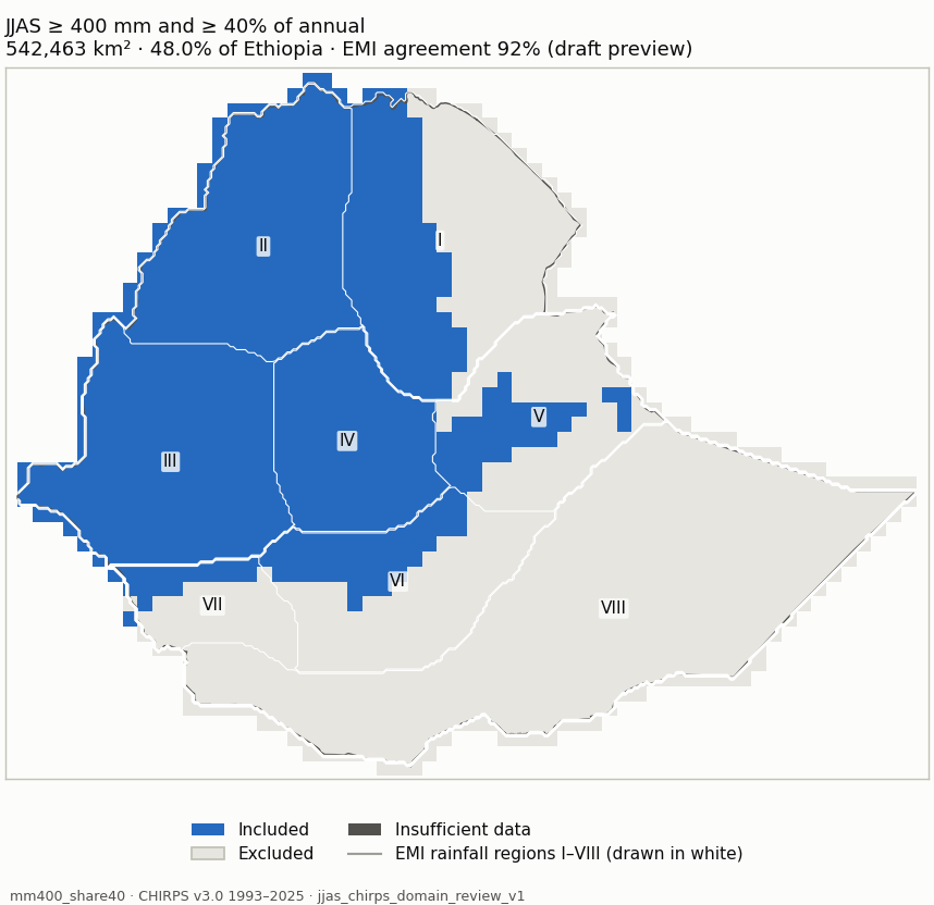
Candidate mm400_share40 (blue: included; dark grey: insufficient data) mm400_share40 Measure Value Included area 542,463 km² (48.0% of Ethiopia) Agreement with EMI-implied membership 92% (visual_only (draft preview); undecided 109,720 km²) Domain files NetCDF · GeoJSON outline Unknown area 4 km² Baseline 1981-2010 unavailable: 12 of 30 years are not in the data (1981-1992); the period is not shortened. Baseline 1991-2020 unavailable: 2 of 30 years are not in the data (1991-1992); the period is not shortened. Baseline 1996-2025 +2,292 km² / −0 km²
Share of each EMI rainfall region included Region Included I Northeast 49.9% II Northwest 100% III Southwest 100% IV Central 100% V East 31.1% VI South Highland 32.1% VII South 25.8% VIII South-Southeast lowlands 0%
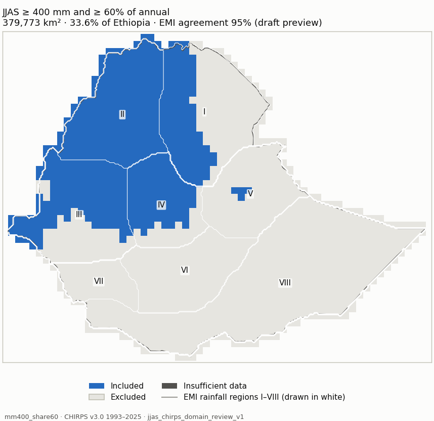
Candidate mm400_share60 (blue: included; dark grey: insufficient data) mm400_share60 Measure Value Included area 379,773 km² (33.6% of Ethiopia) Agreement with EMI-implied membership 95% (visual_only (draft preview); undecided 85,788 km²) Domain files NetCDF · GeoJSON outline Unknown area 4 km² Baseline 1981-2010 unavailable: 12 of 30 years are not in the data (1981-1992); the period is not shortened. Baseline 1991-2020 unavailable: 2 of 30 years are not in the data (1991-1992); the period is not shortened. Baseline 1996-2025 +2,280 km² / −0 km²
Share of each EMI rainfall region included Region Included I Northeast 45.3% II Northwest 100% III Southwest 64.4% IV Central 71.1% V East 3.1% VI South Highland 0% VII South 0% VIII South-Southeast lowlands 0%
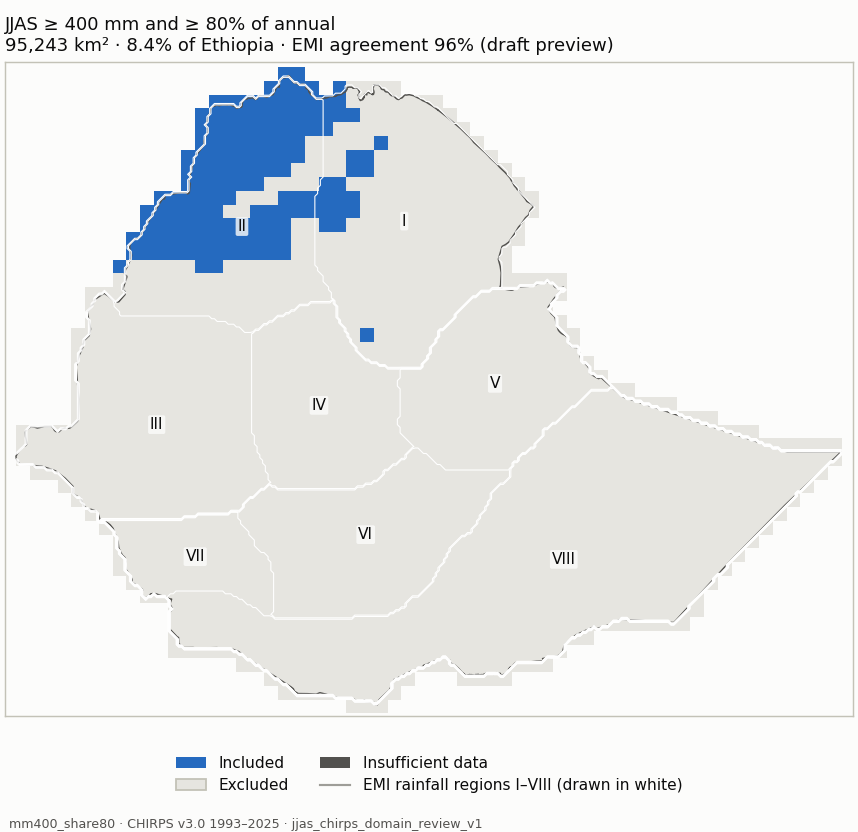
Candidate mm400_share80 (blue: included; dark grey: insufficient data) mm400_share80 Measure Value Included area 95,243 km² (8.4% of Ethiopia) Agreement with EMI-implied membership 96% (visual_only (draft preview); undecided 66,099 km²) Domain files NetCDF · GeoJSON outline Unknown area 4 km² Baseline 1981-2010 unavailable: 12 of 30 years are not in the data (1981-1992); the period is not shortened. Baseline 1991-2020 unavailable: 2 of 30 years are not in the data (1991-1992); the period is not shortened. Baseline 1996-2025 +2,248 km² / −1,502 km²
Share of each EMI rainfall region included Region Included I Northeast 9.8% II Northwest 57.9% III Southwest 0% IV Central 0% V East 0% VI South Highland 0% VII South 0% VIII South-Southeast lowlands 0%
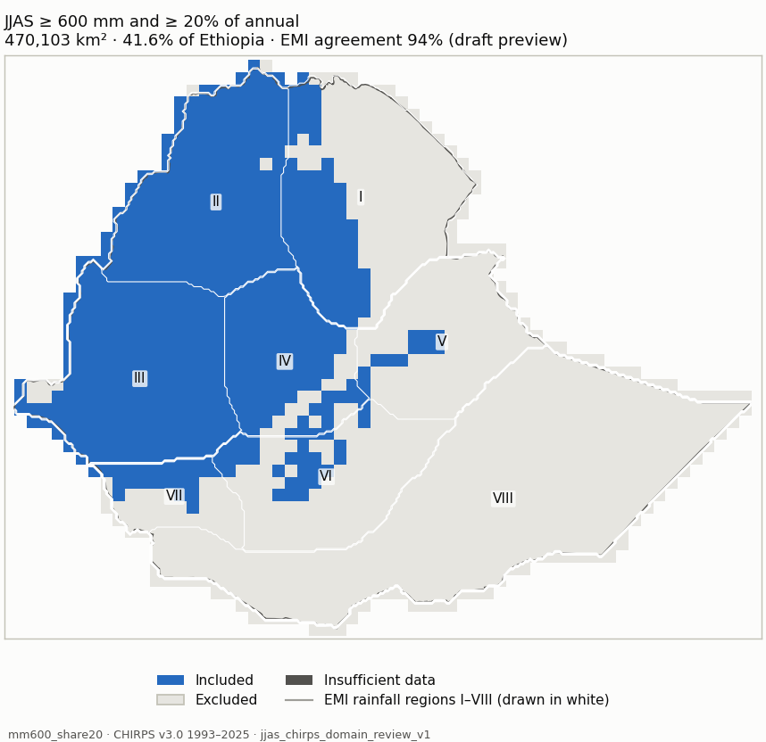
Candidate mm600_share20 (blue: included; dark grey: insufficient data) mm600_share20 Measure Value Included area 470,103 km² (41.6% of Ethiopia) Agreement with EMI-implied membership 94% (visual_only (draft preview); undecided 107,831 km²) Domain files NetCDF · GeoJSON outline Unknown area 4 km² Baseline 1981-2010 unavailable: 12 of 30 years are not in the data (1981-1992); the period is not shortened. Baseline 1991-2020 unavailable: 2 of 30 years are not in the data (1991-1992); the period is not shortened. Baseline 1996-2025 +0 km² / −717 km²
Share of each EMI rainfall region included Region Included I Northeast 36.1% II Northwest 99.4% III Southwest 97.9% IV Central 84% V East 8.6% VI South Highland 19.6% VII South 38.6% VIII South-Southeast lowlands 0%
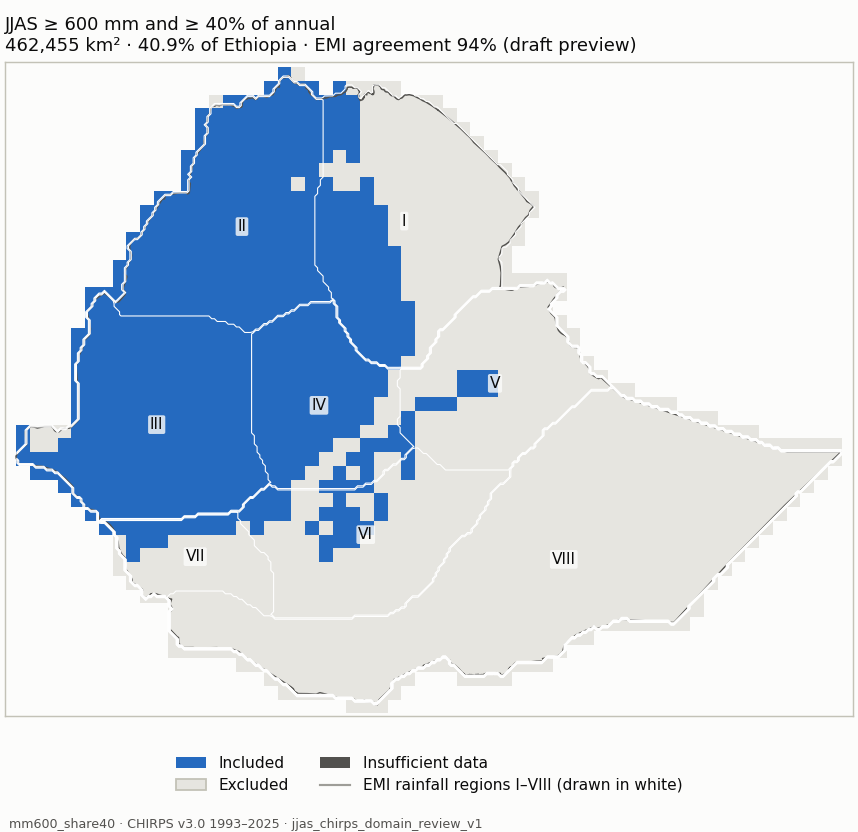
Candidate mm600_share40 (blue: included; dark grey: insufficient data) mm600_share40 Measure Value Included area 462,455 km² (40.9% of Ethiopia) Agreement with EMI-implied membership 94% (visual_only (draft preview); undecided 97,135 km²) Domain files NetCDF · GeoJSON outline Unknown area 4 km² Baseline 1981-2010 unavailable: 12 of 30 years are not in the data (1981-1992); the period is not shortened. Baseline 1991-2020 unavailable: 2 of 30 years are not in the data (1991-1992); the period is not shortened. Baseline 1996-2025 +764 km² / −717 km²
Share of each EMI rainfall region included Region Included I Northeast 36.1% II Northwest 99.4% III Southwest 97.9% IV Central 84% V East 8.6% VI South Highland 18.2% VII South 24.6% VIII South-Southeast lowlands 0%
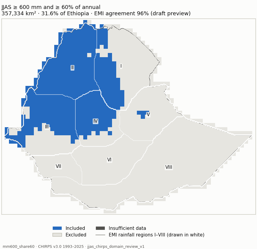
Candidate mm600_share60 (blue: included; dark grey: insufficient data) mm600_share60 Measure Value Included area 357,334 km² (31.6% of Ethiopia) Agreement with EMI-implied membership 96% (visual_only (draft preview); undecided 73,203 km²) Domain files NetCDF · GeoJSON outline Unknown area 4 km² Baseline 1981-2010 unavailable: 12 of 30 years are not in the data (1981-1992); the period is not shortened. Baseline 1991-2020 unavailable: 2 of 30 years are not in the data (1991-1992); the period is not shortened. Baseline 1996-2025 +1,519 km² / −717 km²
Share of each EMI rainfall region included Region Included I Northeast 35.7% II Northwest 99.4% III Southwest 62.2% IV Central 68.7% V East 3.1% VI South Highland 0% VII South 0% VIII South-Southeast lowlands 0%
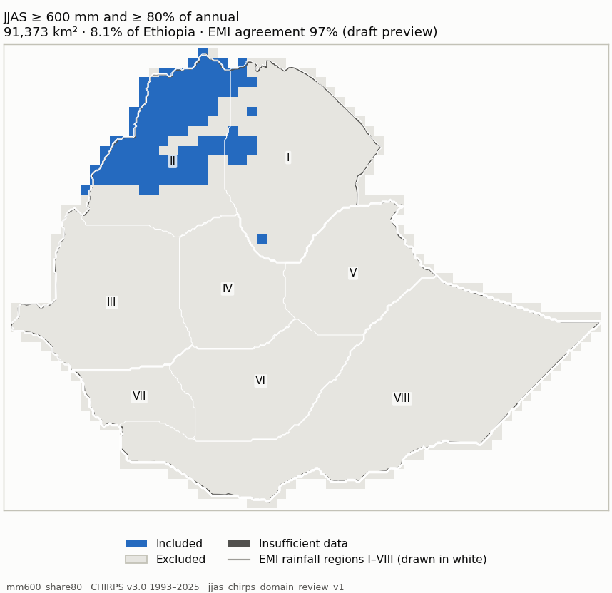
Candidate mm600_share80 (blue: included; dark grey: insufficient data) mm600_share80 Measure Value Included area 91,373 km² (8.1% of Ethiopia) Agreement with EMI-implied membership 97% (visual_only (draft preview); undecided 53,514 km²) Domain files NetCDF · GeoJSON outline Unknown area 4 km² Baseline 1981-2010 unavailable: 12 of 30 years are not in the data (1981-1992); the period is not shortened. Baseline 1991-2020 unavailable: 2 of 30 years are not in the data (1991-1992); the period is not shortened. Baseline 1996-2025 +748 km² / −1,502 km²
Share of each EMI rainfall region included Region Included I Northeast 7.6% II Northwest 57.8% III Southwest 0% IV Central 0% V East 0% VI South Highland 0% VII South 0% VIII South-Southeast lowlands 0%
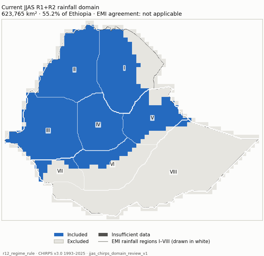
r12_regime_rule (blue: included; dark grey: insufficient data) r12_regime_rule Measure Value Included area 623,765 km² (55.2% of Ethiopia) Agreement with EMI-implied membership Regime membership is not an amount/share threshold, so EMI classes imply no membership for it. Domain files NetCDF · GeoJSON outline
Share of each EMI rainfall region included Region Included I Northeast 72.6% II Northwest 98.3% III Southwest 98.6% IV Central 100% V East 74.9% VI South Highland 33.5% VII South 27.9% VIII South-Southeast lowlands 0.8%
share60_mm200 (blue: included; dark grey: insufficient data) share60_mm200 Measure Value Included area 382,773 km² (33.9% of Ethiopia) Agreement with EMI-implied membership 94% (visual_only (draft preview); undecided 88,068 km²) Domain files NetCDF · GeoJSON outline
Share of each EMI rainfall region included Region Included I Northeast 47.1% II Northwest 100% III Southwest 64.4% IV Central 71.1% V East 3.1% VI South Highland 0% VII South 0% VIII South-Southeast lowlands 0%
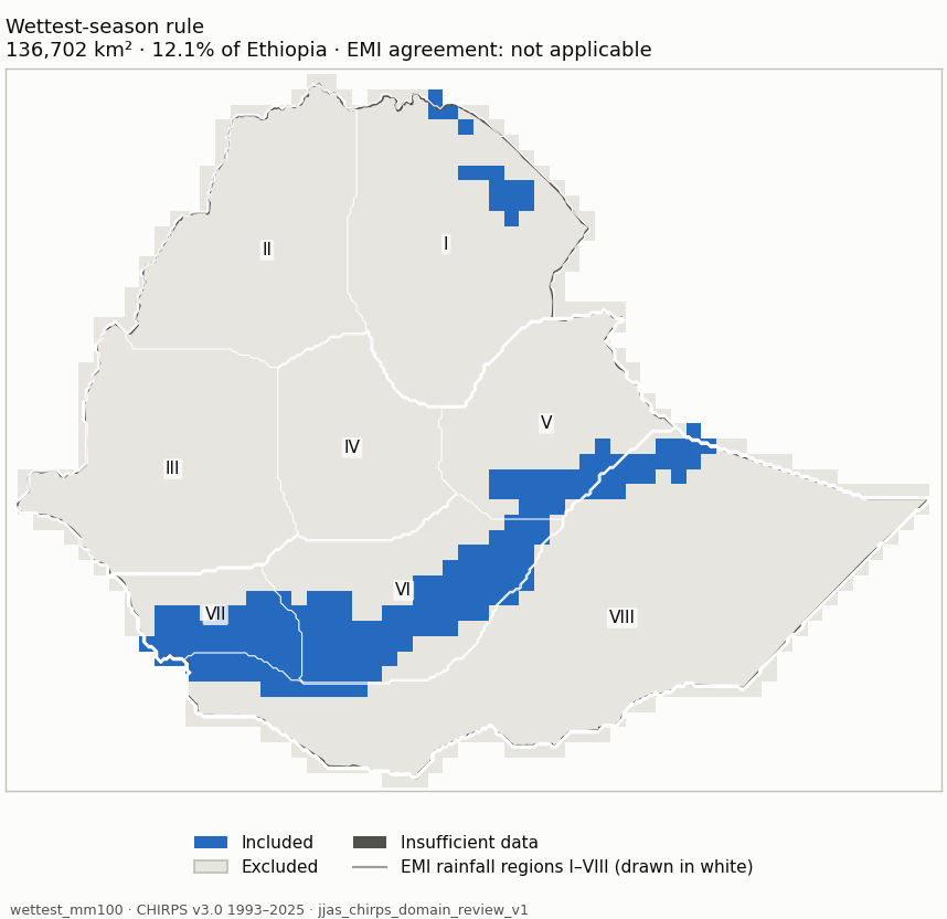
wettest_mm100 (blue: included; dark grey: insufficient data) wettest_mm100 Measure Value Included area 136,702 km² (12.1% of Ethiopia) Agreement with EMI-implied membership Wettest-season membership compares JJAS with FMAM and ONDJ; the EMI maps give no FMAM/ONDJ amounts. Domain files NetCDF · GeoJSON outline
Share of each EMI rainfall region included Region Included I Northeast 5.8% II Northwest 0% III Southwest 0% IV Central 0% V East 16.4% VI South Highland 51.8% VII South 61.6% VIII South-Southeast lowlands 8.4%
Named comparisons Rule Share of Ethiopia Agreement with EMI-implied membership Files Current JJAS R1+R2 rainfall domain: R1/R2 membership, JJAS >= 120 mm and >= 20% of annual 55.2% Regime membership is not an amount/share threshold, so EMI classes imply no membership for it. NetCDF · GeoJSON 60% contribution rule: JJAS >= 60% of annual and >= 200 mm (no cleanup) 33.9% 94% NetCDF · GeoJSON Wettest-season rule: JJAS wetter than FMAM and ONDJ, >= 100 mm (no cleanup) 12.1% Wettest-season membership compares JJAS with FMAM and ONDJ; the EMI maps give no FMAM/ONDJ amounts. NetCDF · GeoJSON
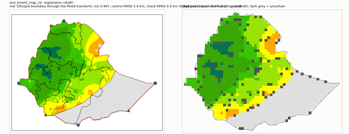
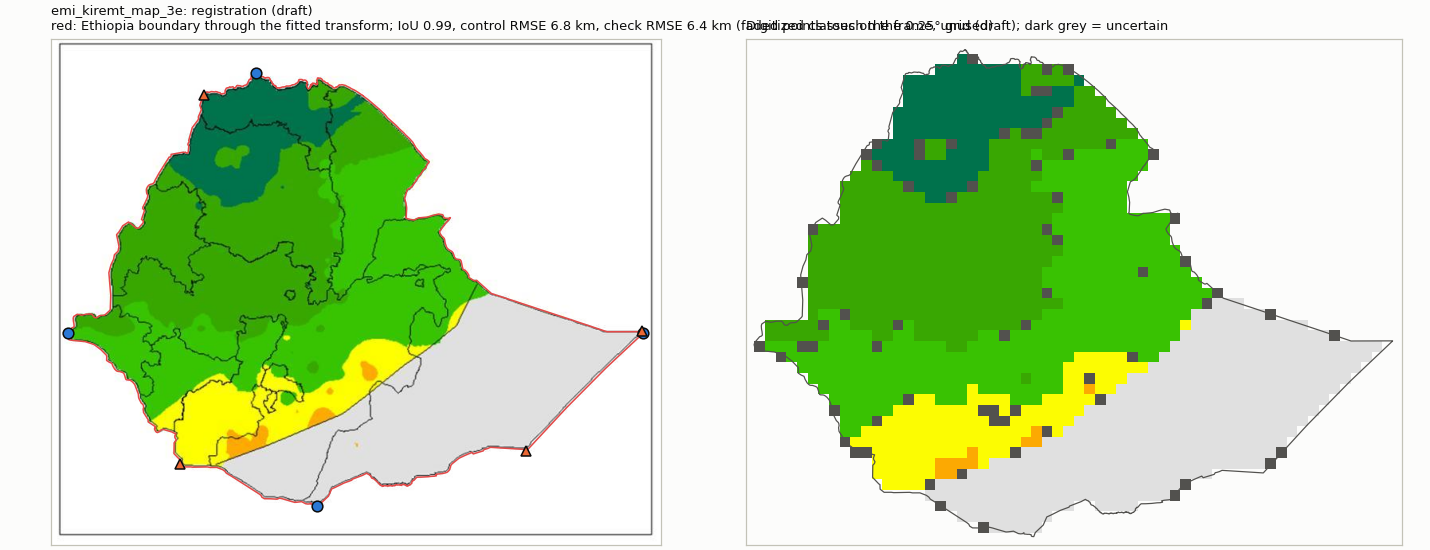
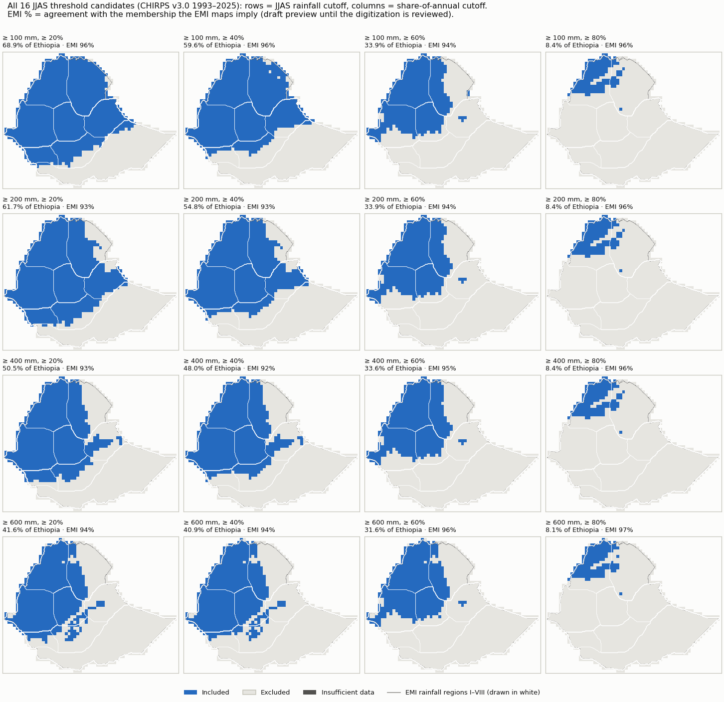
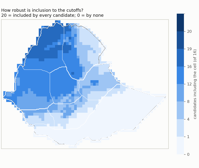
Named comparisons side by side All threshold candidates (rows: rainfall cutoff; columns: share cutoff) Included share of Ethiopia for each candidate How many candidates include each cell Regional inclusion by candidate Agreement of CHIRPS with the EMI classes Reference Mode Exact class Within one class CHIRPS wetter / drier Outside the class interval (median / 90th pct) Comparable / uncertain area emi_kiremt_map_2e visual only (unreviewed preview) 68% 96% 17% / 15% 4.3 / 126.6 mm 1,033,891 km² / 76,084 km² emi_kiremt_map_3e visual only (unreviewed preview) 76% 98% 12% / 12% 0.0 / 4.7 pp 1,067,462 km² / 44,901 km²
Largest changes between neighbouring cutoffs From To Changed Area switching mm100_share40 mm100_share60 annual share percent 289,940 km² mm100_share60 mm100_share80 annual share percent 287,789 km² mm200_share60 mm200_share80 annual share percent 287,530 km² mm400_share60 mm400_share80 annual share percent 284,530 km² mm600_share60 mm600_share80 annual share percent 265,961 km² mm200_share40 mm200_share60 annual share percent 236,573 km²
Baseline sensitivity of mm100_share20 Candidates nested (raising a cutoff never adds a cell): yes. Dataset sensitivity: not assessed (CHIRPS only).