Official outlook comparison — FMAM 2026
Season: FMAM 2026 (1 Feb 2026 – 31 May 2026) · Area: FMAM rainfall contribution domain
Official outlooks from ICPAC and the Ethiopian Meteorology Institute (EMI), compared with this platform's forecast, using only values a person has checked against the published figures. The first parts describe agreement between the outlooks; Against CHIRPS observations scores each of them against what was observed this season.
Key findings — FMAM rainfall contribution domain
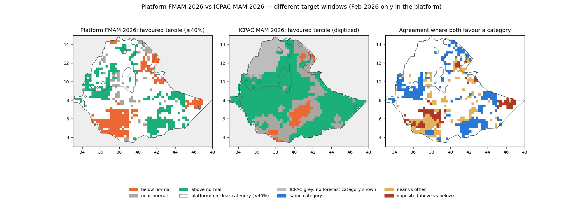
- ICPAC — FMAM rainfall contribution domain. Category agreement of 45.4% within the compared area, which covers 39% of the analysed domain. Predominant category in both: above normal. Periods differ (Mar 2026–May 2026 vs Feb 2026–May 2026).Evidence: Platform map (domain) · Platform data (NetCDF) · Official figure · Original file · Comparison map · Source record
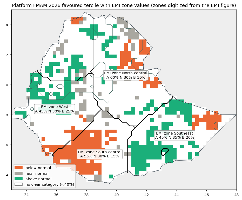
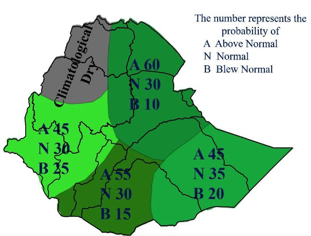
- EMI — whole zones. Platform area mean of local probabilities over each EMI zone, below / near / above: zone West: no clear category in one source, platform 32% / 33% / 35% over the whole zone (76% of it in the domain); zone North-central: no clear category in one source, platform 34% / 32% / 34% over the whole zone (73% of it in the domain); zone South-central: no clear category in one source, platform 39% / 32% / 29%; zone Southeast: no clear category in one source, platform 34% / 27% / 39% over the whole zone (99% of it in the domain). Zone boundaries: the zone polygons digitized from the EMI figure (georeferenced by fitting the country outline).Evidence: Official figure · Original PDF page · Platform map (All Ethiopia) · Platform data (NetCDF) · Source record
- Robustness of the extraction. With the ICPAC map as digitized and shifted by one source pixel in each direction, the All Ethiopia category agreement stays between 45.8% and 48.4%. With the ICPAC map as digitized and shifted by one source pixel in each direction, the FMAM rainfall contribution domain category agreement stays between 43.6% and 45.9%. With the ICPAC map as digitized and shifted by one source pixel in each direction, the FMAM main-season rainfall domain (Belg / Gu / Ganna, >=40% of annual) category agreement stays between 48.2% and 50.9%. These are bounded sensitivity checks of the extraction, not statistical confidence intervals; exact EMI zone comparisons remain unavailable.
| Area | Compared area (share of the analysed area) | Category agreement within it | Opposite categories within it |
|---|---|---|---|
| All Ethiopia (national context) | 34% | 47.8% | 17.4% |
| FMAM rainfall contribution domain | 39% | 45.4% | 19.4% |
| Location | Official | Platform over the whole zone | Observed area share, Feb–May 2026 below / near / above | Evidence |
|---|---|---|---|---|
| Zone South-central Entire sample in the domain | 15% / 30% / 55% | 39% / 32% / 29% No clear category in one source | 16% / 34% / 50% | Platform map (domain) · Platform data (NetCDF) · Official figure · Original PDF page |
| Zone Southeast Partly overlaps the domain — 99% of sample cells | 20% / 35% / 45% | 34% / 27% / 39% No clear category in one source · 99% of the zone in the selected domain | 31% / 51% / 18% | Platform map (All Ethiopia) · Platform data (NetCDF) · Official figure · Original PDF page |
| Zone West Partly overlaps the domain — 76% of sample cells | 25% / 30% / 45% | 32% / 33% / 35% No clear category in one source · 76% of the zone in the selected domain | 0% / 12% / 88% | Platform map (All Ethiopia) · Platform data (NetCDF) · Official figure · Original PDF page |
| Zone North-central Partly overlaps the domain — 73% of sample cells | 10% / 30% / 60% | 34% / 32% / 34% No clear category in one source · 73% of the zone in the selected domain | 2% / 52% / 46% | Platform map (All Ethiopia) · Platform data (NetCDF) · Official figure · Original PDF page |
Platform values are area means of local probabilities. Each zone is EMI's own zone as drawn in its figure for this outlook, digitized from that figure and placed by fitting the country outline (approximate boundaries). Observed area shares describe where the observed rainfall fell into each category; they are not probabilities. Percentages are rounded to add up to 100%.
| Location | ICPAC (favoured category, printed interval) | Platform | Relationship | Observed area share, Mar–May 2026 below / near / above | Observed area share, Feb–May 2026 below / near / above | Evidence |
|---|---|---|---|---|---|---|
| Within zone South-central Entire sample in the domain | Near normal 33–40% 48% of shown cells; also Above normal 40–50% (32%), Below normal 40–50% (20%) | 39% / 32% / 29% | No clear category in one source | 15% / 30% / 55% | 16% / 34% / 50% | Platform map (domain) · Platform data (NetCDF) · Official figure · Original file · Comparison map |
| Within zone Southeast Partly overlaps the domain — 99% of sample cells | Above normal 40–50% 77% of shown cells; also Near normal 33–40% (19%), Below normal 40–50% (4%) | 34% / 27% / 39% | No clear category in one source | 30% / 50% / 20% | 31% / 51% / 18% | Platform map (All Ethiopia) · Platform data (NetCDF) · Official figure · Original file · Comparison map |
| Within zone West Partly overlaps the domain — 76% of sample cells | Above normal 40–50% 60% of shown cells; also Above normal 50–60% (36%), Near normal 33–40% (5%) | 32% / 33% / 35% | No clear category in one source | 0% / 12% / 88% | 0% / 12% / 88% | Platform map (All Ethiopia) · Platform data (NetCDF) · Official figure · Original file · Comparison map |
| Within zone North-central Partly overlaps the domain — 73% of sample cells | Above normal 40–50% 57% of shown cells; also Near normal 33–40% (33%), Below normal 40–50% (5%), Above normal 50–60% (5%), Above normal 33–40% (<1%); 4% of the sample grey (no forecast category shown) | 34% / 32% / 34% | No clear category in one source | 2% / 40% / 58% | 2% / 52% / 46% | Platform map (All Ethiopia) · Platform data (NetCDF) · Official figure · Original file · Comparison map |
| FMAM rainfall contribution domain selected area | Above normal (most often 40–50%) shown on >99% of the area; <1% grey (no forecast category shown) | 35% / 31% / 34% | Same category (where both show a category) | 13% / 35% / 52% | 13% / 40% / 47% | Platform map (domain) · Platform data (NetCDF) · Official figure · Original file · Comparison map |
| All Ethiopia national context | Above normal (most often 40–50%) shown on 89% of the area; 11% grey (no forecast category shown) | 34% / 31% / 35% | Same category (where both show a category) | 11% / 33% / 56% | 11% / 37% / 52% | Platform map (All Ethiopia) · Platform data (NetCDF) · Official figure · Original file · Comparison map |
ICPAC publishes only the favoured category and its probability interval (the other two categories are not published), for 1 Mar 2026 – 31 May 2026; the platform covers 1 Feb 2026 – 31 May 2026, so the two are compared as tendencies, not as the same event. Locations are the EMI arrow-tip boxes or the digitized EMI zones; platform values are area means of local probabilities over each location or area. Observed area shares describe where the observed rainfall fell into each category over that location, for each period; they are not probabilities.
Against CHIRPS observations — FMAM rainfall contribution domain
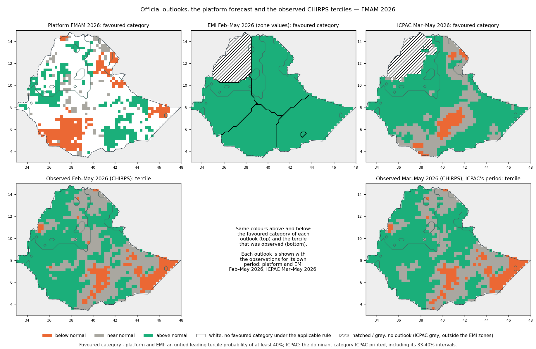
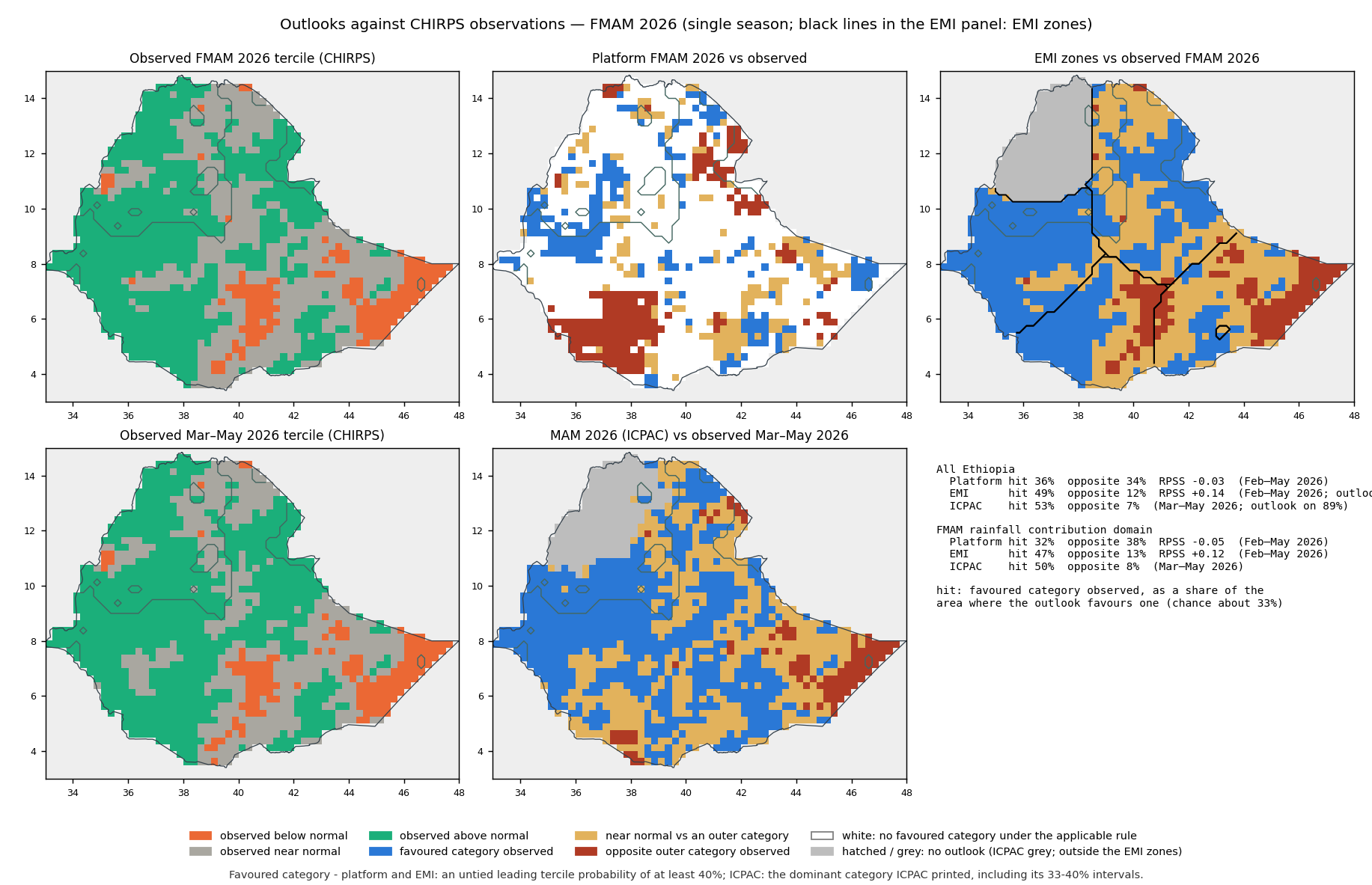
Each outlook is scored against what CHIRPS observed for its own period, with observed terciles from CHIRPS 1993–2025 in each 0.25° cell. One season only: these numbers describe 2026, not general skill.
| Outlook | Period | Observations available | Outlook issued | Favoured category shown | Favoured category observed | Opposite category observed | Chance | RPSS vs climatology |
|---|---|---|---|---|---|---|---|---|
| Platform — FMAM 2026 | Feb–May 2026 | 100% | 100% | 39% | 32% | 38% | 33% | −0.05 |
| EMI — Belg (FMAM) 2026 | Feb–May 2026 | 100% | 100% | 100% | 47% | 13% | 33% | +0.12 |
| ICPAC — MAM 2026 | Mar–May 2026 | 100% | 100% | 100% 27% of it on the 33–40% interval | 50% | 8% | 33% | not computed |
Observations available: share of the area with usable CHIRPS observations. Outlook issued: share of those cells where the provider issued an outlook (ICPAC's grey areas and EMI's excluded dry areas have none). Favoured category shown: share where the provider's rule selects a category — for the platform and EMI an untied leading probability of at least 40%; for ICPAC the dominant category ICPAC printed, including its 33–40% intervals (the share resting on 33–40% is given). Favoured category observed: within those cells, the share where that category was observed; chance is the climatological probability of that category there (about one in three). RPSS: ranked probability skill score against the CHIRPS climatology over the cells with an outlook (positive is better than climatology); ICPAC publishes only the favoured category and its interval, so its other probabilities are not inferred and no RPSS is computed.
| EMI zone | Observed area share below / near / above | EMI | Platform | ICPAC (Mar–May 2026) |
|---|---|---|---|---|
| West EMI: B 25% N 30% A 45% | 0% / 12% / 88% | 88% · RPSS +0.31 | 64% · RPSS +0.05 | 87% |
| North-central EMI: B 10% N 30% A 60% | 2% / 52% / 46% | 46% · RPSS +0.23 | 34% · RPSS −0.03 | 48% |
| South-central EMI: B 15% N 30% A 55% | 16% / 34% / 50% | 50% · RPSS +0.13 | 9% · RPSS −0.21 | 45% |
| Southeast EMI: B 20% N 35% A 45% | 31% / 51% / 18% | 18% · RPSS −0.16 | 33% · RPSS −0.01 | 30% |
Observed area shares are for Feb–May 2026 and describe where the observed rainfall fell into each category (not probabilities); the ICPAC column is scored against its own period. Each zone is evaluated as a whole, whichever domain is selected.
National context (All Ethiopia)
- ICPAC — All Ethiopia. Category agreement of 47.8% within the compared area, which covers 34% of the analysed national area. Predominant category in both: above normal. Periods differ (Mar 2026–May 2026 vs Feb 2026–May 2026).Evidence: Platform map (All Ethiopia) · Platform data (NetCDF) · Official figure · Original file · Comparison map · Source record
- EMI — whole zones. Platform area mean of local probabilities over each EMI zone, below / near / above: zone West: no clear category in one source, platform 32% / 33% / 35%; zone North-central: no clear category in one source, platform 34% / 32% / 34%; zone South-central: no clear category in one source, platform 39% / 32% / 29%; zone Southeast: no clear category in one source, platform 34% / 27% / 39%. Zone boundaries: the zone polygons digitized from the EMI figure (georeferenced by fitting the country outline).Evidence: Official figure · Original PDF page · Platform map (All Ethiopia) · Platform data (NetCDF) · Source record
Detailed interpretation
The outlooks favour different categories over much of their shared displayed area in the FMAM rainfall contribution domain. ICPAC shows a favoured category on >99% of the FMAM rainfall contribution domain and no forecast category shown (the legend does not explain the grey areas) on <1%; where it shows one it favours above normal on 66%, most often at 40-50% and 33-40%. The platform favours above normal on 18% and below normal on 17% of the FMAM rainfall contribution domain. There is category agreement of 45.4% within the compared area, which covers 39% of the analysed domain; opposite categories (above vs below) on 19% of the compared area. ICPAC publishes only the favoured category and its probability interval, so probabilities are not differenced. The official outlook covers Mar 2026–May 2026 and the platform Feb 2026–May 2026 (Feb 2026 only in the platform), so this compares spatial tendencies, not probabilities for the same seasonal event.Evidence: Platform map (domain) · Platform data (NetCDF) · Official figure · Original file · Comparison map
The platform does not show a unique favoured category over EMI zone West under its applicable rule. EMI prints 25% / 30% / 45% (below / near / above). Over the whole zone (as digitized from the EMI figure), the platform area mean is 32% / 33% / 35%: no clear category in one source.Evidence: Platform map (All Ethiopia) · Platform data (NetCDF) · Official figure · Original PDF page
The platform does not show a unique favoured category over EMI zone North-central under its applicable rule. EMI prints 10% / 30% / 60% (below / near / above). Over the whole zone (as digitized from the EMI figure), the platform area mean is 34% / 32% / 34%: no clear category in one source.Evidence: Platform map (All Ethiopia) · Platform data (NetCDF) · Official figure · Original PDF page
The platform does not show a unique favoured category over EMI zone South-central under its applicable rule. EMI prints 15% / 30% / 55% (below / near / above). Over the whole zone (as digitized from the EMI figure), the platform area mean is 39% / 32% / 29%: no clear category in one source.Evidence: Platform map (All Ethiopia) · Platform data (NetCDF) · Official figure · Original PDF page
The platform does not show a unique favoured category over EMI zone Southeast under its applicable rule. EMI prints 20% / 35% / 45% (below / near / above). Over the whole zone (as digitized from the EMI figure), the platform area mean is 34% / 27% / 39%: no clear category in one source.Evidence: Platform map (All Ethiopia) · Platform data (NetCDF) · Official figure · Original PDF page
The EMI zones were digitized from the figure's fill colours and placed by fitting the country outline, so their boundaries are approximate; the figure states no reference period, so probability differences are not calculated.
National context: The outlooks favour different categories over much of their shared displayed area in Ethiopia. ICPAC shows a favoured category on 89% of Ethiopia and no forecast category shown (the legend does not explain the grey areas) on 11%; where it shows one it favours above normal on 68%, most often at 40-50% and 33-40%. The platform favours above normal on 18% and below normal on 14% of Ethiopia. There is category agreement of 47.8% within the compared area, which covers 34% of the analysed national area; opposite categories (above vs below) on 17% of the compared area. ICPAC publishes only the favoured category and its probability interval, so probabilities are not differenced. The official outlook covers Mar 2026–May 2026 and the platform Feb 2026–May 2026 (Feb 2026 only in the platform), so this compares spatial tendencies, not probabilities for the same seasonal event.Evidence: Platform map (All Ethiopia) · Platform data (NetCDF) · Official figure · Original file · Comparison map
Not calculated: rainfall-anomaly differences, because no official rainfall-amount anomaly product was found in the checked ICPAC and EMI products; same-event probability differences, because the target windows or spatial supports differ and ICPAC publishes only favoured-category intervals.
Single-season performance against CHIRPS observations is now evaluated (see Against CHIRPS observations). One season does not establish that any provider, or the platform, is generally more skilful.
Sources, extraction review and methods
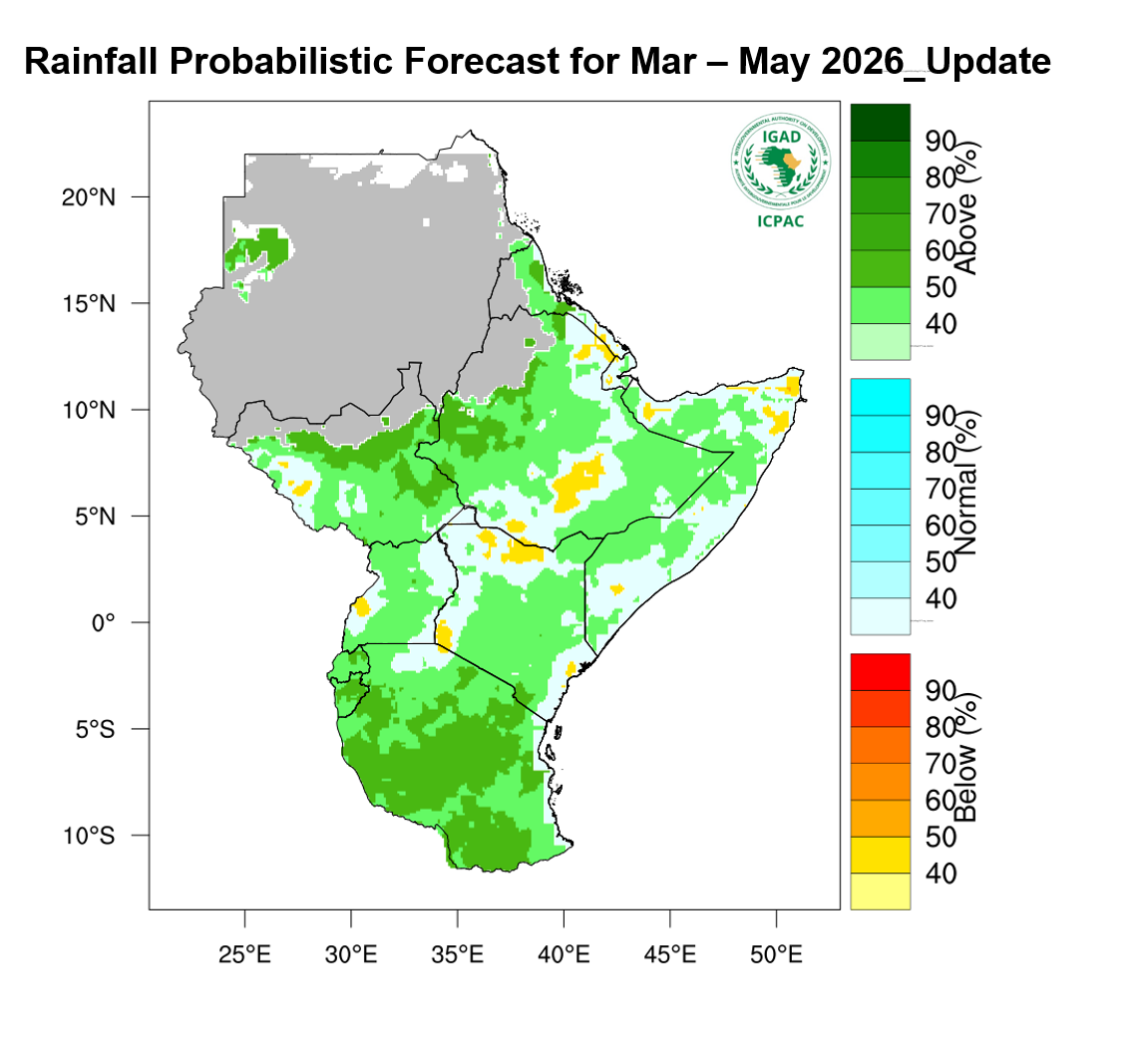
ICPAC: MAM 2026
Extraction reviewed Checked 2026-10-09: new product, reviewed

Wetter than normal conditions expected over most parts of Ethiopia, parts of northern and central and southern Somalia, northern Eritrea, South Sudan, central to southern Kenya, Uganda, Rwanda, Burundi, and Tanzania.
Normal to drier than normal conditions are expected over western and northern Kenya, western and eastern Uganda, south-western to central and north-eastern Ethiopia, Djibouti, western South Sudan and most parts of Somalia.
— ICPAC, detail page, rainfall forecast item
EMI: Belg (FMAM) 2026
Extraction reviewed Checked 2026-10-09: new product, reviewed
Summery and advisory for coming Belg (FMAM), 2026 For Belg 2026, rainfall in the Belg-benefiting catchments is anticipated to be normal to above normal Rainfall condition. February is expected to remain mostly dry, while from March through May, the catchments are likely to experience better conditions, to increase the availability of surface water and groundwater recharge. Tercile probability on basin map for coming belg 2026 Season During the coming Belg 2026 season (typically February to May), meteorological forecasts indicate that Most of Belg Benefiting catchments are likely to receive above Normal rainfall amounts over Most of Genale dawa, and lower Reft vally and close to normal or above normal rainfall condition over Wabeshebele, Awash Afar Denakel, Ommo Gibe, Baro Akobo and Upper and Middle Abay Basins. This pattern has important implications for both surface water discharge (riv
— EMI, PDF page 22
| Comparison | Where | Status | Why |
|---|---|---|---|
| Official probabilities shown | EMI zone West | available | |
| Favoured-category relationship | EMI zone West | unavailable | reviewed visual (arrow-tip neighbourhood) |
| Platform mean over the official zone | EMI zone West | available | zone polygons digitized from the EMI figure |
| Probability difference for the same event | EMI zone West | unavailable | the zone boundary is not published with the figure; the official reference period is not stated |
| Official probabilities shown | North-central | available | |
| Favoured-category relationship | North-central | unavailable | reviewed visual (arrow-tip neighbourhood) |
| Platform mean over the official zone | North-central | available | zone polygons digitized from the EMI figure |
| Probability difference for the same event | North-central | unavailable | the zone boundary is not published with the figure; the official reference period is not stated |
| Official probabilities shown | South-central | available | |
| Favoured-category relationship | South-central | unavailable | reviewed visual (arrow-tip neighbourhood) |
| Platform mean over the official zone | South-central | available | zone polygons digitized from the EMI figure |
| Probability difference for the same event | South-central | unavailable | the zone boundary is not published with the figure; the official reference period is not stated |
| Official probabilities shown | Southeast | available | |
| Favoured-category relationship | Southeast | unavailable | reviewed visual (arrow-tip neighbourhood) |
| Platform mean over the official zone | Southeast | available | zone polygons digitized from the EMI figure |
| Probability difference for the same event | Southeast | unavailable | the zone boundary is not published with the figure; the official reference period is not stated |
| Mapped category agreement | All Ethiopia | available | reviewed digitization |
| Mapped category agreement | FMAM rainfall contribution domain | available | reviewed digitization |
| Mapped category agreement | FMAM main-season rainfall domain (Belg / Gu / Ganna, >=40% of annual) | available | reviewed digitization |
| Probability difference for the same event | — | unavailable | the target periods differ; only the favoured category and its interval are published |
| Rainfall anomaly difference | — | unavailable | no official rainfall-amount anomaly product was found in the checked products |
| Which forecast is more accurate | — | available | single-season scores against CHIRPS observations (see Against CHIRPS observations) |
- Area means are area-weighted means of local grid-cell probabilities, not probabilities of area-mean rainfall.
- Favoured category: for the platform and EMI, the untied leading tercile where it reaches 40% (the map display rule), otherwise no clear category; for ICPAC, the dominant category ICPAC printed, including its 33–40% intervals.
- ICPAC covers Mar–May 2026 and the platform Feb–May 2026: a probability for one period cannot be built by averaging monthly probabilities of the other, so they are compared only as spatial tendencies.